New Quay geodata
New Quay (Wales) is a seat of a third-order administrative division; located in United Kingdom in Europe/London (GMT+1) time zone. With population of 694 people, there are 4284 cities with bigger population in this country. Compared to other cities in United Kingdom, 56.2% of cities are located further ↑North; 91.9% of cities are located further →East and 79.9% of cities have higher elevation than New Quay. Note1


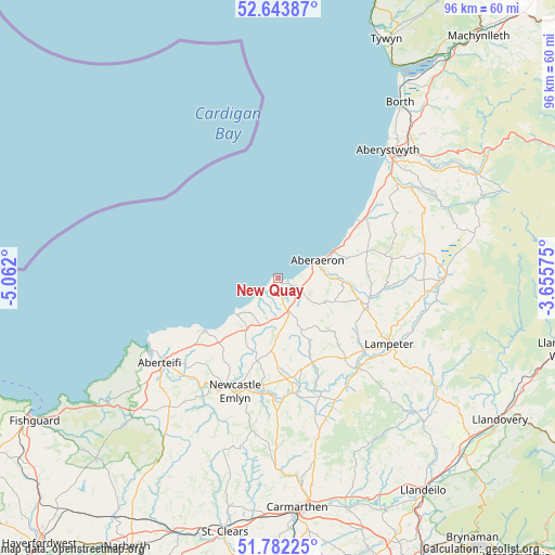
New Quay GPS coordinates[2]
52° 12' 54.54" North, 4° 21' 31.932" West
| Map corner | latitude | longitude |
|---|---|---|
| Upper-left | 52.64387°, | -5.062° |
| Center: | 52.21515°, | -4.35887° |
| Lower-right: | 51.78225°, | -3.65575° |
| Map W x H: | 95.8×95.8 km | = 59.5×59.5mi |
| max Lat: | 60.39635° ⇑56.2% North |
| New Quay: | 52.21515° |
| min Lat: | ⇓43.8% South 34.60088° |
| min Long | New Quay | max Long |
| -7.64133° | -4.35887° | 32.95536° |
| W 8.1%⇐ | ⇒91.9% E |
Elevation
Elevation of New Quay is 21 m = 69 ft, and this is 51.9 m = 170 ft below average elevation for this country.
| Max E: |
515 m = 1690 ft | 79.9% |
| Avg. | 72.9 m = 239 ft | |
| New Quay | 21 m = 69 ft | |
Min E: |
-30 m = -98 ft | 20.1% |
See also: United Kingdom elevation on elevation.city.
Geographical zone
New Quay is located in North temperate zone (between Tropic of Cancer and the Arctic Circle). Distance of this North polar circle is 1595.4 km =991.3 mi to North.| Distance of | km | miles | from New Quay |
|---|---|---|---|
| North Pole | 4201.3 | 2610.6 | to North |
| Arctic Circle | 1595.4 | 991.3 | to North |
| Tropic Cancer | 3199.9 | 1988.3 | to South |
| Equator | 5805.8 | 3607.6 | to South |


Nearby cities:
15 places around New Quay: (largest is in red/bold)
• Aberaeron
7.5 km =4.7 mi,  65°
65°
• Aberporth
15.5 km =9.6 mi,  233°
233°
• Cardigan
25.3 km =15.7 mi, 234°
• Cwmann
23.7 km =14.7 mi,  121°
121°
• Henfynyw Upper
6 km =3.7 mi,  80°
80°
• Lampeter
22.1 km =13.7 mi, 120°
• Llan-non
14.4 km =8.9 mi,  59°
59°
• Llanarth
4.2 km =2.6 mi, 123°
• Llandysul
19.6 km =12.2 mi,  170°
170°
• Llangybi
22.3 km =13.9 mi,  108°
108°
• Llanllwchaiarn
3.6 km =2.2 mi,  188°
188°
• Llanrhystud
17.7 km =11 mi, 55°
• Llechryd
23.6 km =14.7 mi, 226°
• Newcastle Emlyn
20.8 km =12.9 mi,  200°
200°
• Pencader
24.7 km =15.3 mi, 165°
Sources, notices
• [Note1] Compared only with cities in United Kingdom existing in our database
• [Src1] Map data: © OpenStreetMap contributors (CC-BY-SA)
• [Src2] Other city data from geonames.org with taken over terms of usage.
• [Src3] Geographical zone / Annual Mean Temperature by Robert A. Rohde @ Wikipedia
