Newcastle Emlyn geodata
Newcastle Emlyn (Wales) is a populated place; located in United Kingdom in Europe/London (GMT+1) time zone. With population of 1,883 people, there are 2713 cities with bigger population in this country. Compared to other cities in United Kingdom, 61% of cities are located further ↑North; 92.9% of cities are located further →East and 71.6% of cities have higher elevation than Newcastle Emlyn. Note1


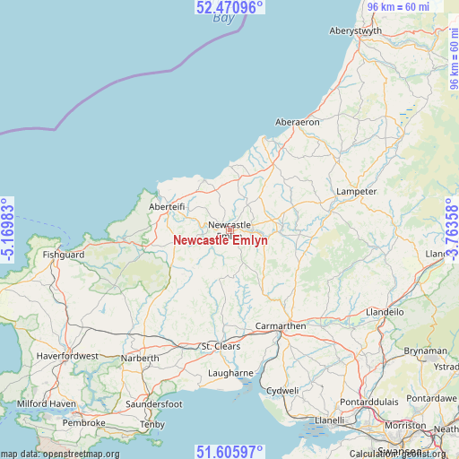
Newcastle Emlyn GPS coordinates[2]
52° 2' 26.016" North, 4° 28' 0.12" West
| Map corner | latitude | longitude |
|---|---|---|
| Upper-left | 52.47096°, | -5.16983° |
| Center: | 52.04056°, | -4.4667° |
| Lower-right: | 51.60597°, | -3.76358° |
| Map W x H: | 96.2×96.2 km | = 59.8×59.8mi |
| max Lat: | 60.39635° ⇑61% North |
| Newcastle Emlyn: | 52.04056° |
| min Lat: | ⇓39% South 34.60088° |
| min Long | Newcastle Emlyn | max Long |
| -7.64133° | -4.4667° | 32.95536° |
| W 7.1%⇐ | ⇒92.9% E |
Elevation
Elevation of Newcastle Emlyn is 31 m = 102 ft, and this is 41.9 m = 137 ft below average elevation for this country.
| Max E: |
515 m = 1690 ft | 71.6% |
| Avg. | 72.9 m = 239 ft | |
| Newcastle Emlyn | 31 m = 102 ft | |
Min E: |
-30 m = -98 ft | 28.4% |
See also: United Kingdom elevation on elevation.city.
Geographical zone
Newcastle Emlyn is located in North temperate zone (between Tropic of Cancer and the Arctic Circle). Distance of this North polar circle is 1614.8 km =1003.4 mi to North.| Distance of | km | miles | from Newcastle Emlyn |
|---|---|---|---|
| North Pole | 4220.7 | 2622.6 | to North |
| Arctic Circle | 1614.8 | 1003.4 | to North |
| Tropic Cancer | 3180.4 | 1976.2 | to South |
| Equator | 5786.4 | 3595.5 | to South |


Nearby cities:
15 places around Newcastle Emlyn: (largest is in red/bold)
• Abernant
18 km =11.2 mi,  168°
168°
• Aberporth
11.4 km =7.1 mi,  333°
333°
• Cardigan
14.2 km =8.8 mi,  289°
289°
• Cilgerran
11.4 km =7.1 mi,  278°
278°
• Crymych
14.4 km =8.9 mi,  238°
238°
• Glandwr
16.9 km =10.5 mi,  222°
222°
• Llanarth
20.2 km =12.6 mi,  32°
32°
• Llanboidy
19.9 km =12.4 mi,  205°
205°
• Llandysul
10.8 km =6.7 mi,  89°
89°
• Llanllwchaiarn
17.3 km =10.7 mi,  23°
23°
• Llanwinio
15.3 km =9.5 mi,  196°
196°
• Llechryd
10.1 km =6.3 mi, 287°
• Meidrim
20 km =12.4 mi,  183°
183°
• Pencader
14.4 km =8.9 mi,  107°
107°
• Trelech
10.9 km =6.8 mi,  192°
192°
Sources, notices
• [Note1] Compared only with cities in United Kingdom existing in our database
• [Src1] Map data: © OpenStreetMap contributors (CC-BY-SA)
• [Src2] Other city data from geonames.org with taken over terms of usage.
• [Src3] Geographical zone / Annual Mean Temperature by Robert A. Rohde @ Wikipedia
