Trelech geodata
Trelech (Wales) is a seat of a third-order administrative division; located in United Kingdom in Europe/London (GMT+1) time zone. In our database, there are 4977 cities with bigger population. Compared to other cities in United Kingdom, 63.8% of cities are located further ↑North; 93.2% of cities are located further →East and 95.6% of cities have lower elevation than Trelech. Note1


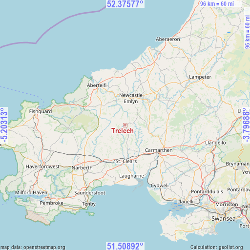
Trelech GPS coordinates[2]
51° 56' 39.984" North, 4° 30' 0" West
| Map corner | latitude | longitude |
|---|---|---|
| Upper-left | 52.37577°, | -5.20313° |
| Center: | 51.94444°, | -4.5° |
| Lower-right: | 51.50892°, | -3.79688° |
| Map W x H: | 96.4×96.4 km | = 59.9×59.9mi |
| max Lat: | 60.39635° ⇑63.8% North |
| Trelech: | 51.94444° |
| min Lat: | ⇓36.2% South 34.60088° |
| min Long | Trelech | max Long |
| -7.64133° | -4.5° | 32.95536° |
| W 6.8%⇐ | ⇒93.2% E |
Elevation
Elevation of Trelech is 190 m = 623 ft, and this is 117.1 m = 384 ft above average elevation for this country.
| Max E: |
515 m = 1690 ft | 4.4% |
| Trelech | 190 m 623 ft | |
| Avg. | 72.9 m = 239 ft | |
Min E: |
-30 m = -98 ft | 95.6% |
See also: United Kingdom elevation on elevation.city.
Geographical zone
Trelech is located in North temperate zone (between Tropic of Cancer and the Arctic Circle). Distance of this North polar circle is 1625.5 km =1010 mi to North.| Distance of | km | miles | from Trelech |
|---|---|---|---|
| North Pole | 4231.4 | 2629.3 | to North |
| Arctic Circle | 1625.5 | 1010 | to North |
| Tropic Cancer | 3169.8 | 1969.6 | to South |
| Equator | 5775.7 | 3588.9 | to South |


Nearby cities:
15 places around Trelech: (largest is in red/bold)
• Abernant
9.1 km =5.7 mi,  140°
140°
• Carmarthen
16.6 km =10.3 mi,  126°
126°
• Cilgerran
15.3 km =9.5 mi,  323°
323°
• Crymych
10.6 km =6.6 mi,  287°
287°
• Glandwr
9.3 km =5.8 mi,  258°
258°
• Llanboidy
9.7 km =6 mi,  221°
221°
• Llanddowror
16 km =9.9 mi,  187°
187°
• Llandysul
17 km =10.6 mi,  50°
50°
• Llangynog
15 km =9.3 mi,  155°
155°
• Llanwinio
4.5 km =2.8 mi,  207°
207°
• Llechryd
15.6 km =9.7 mi,  331°
331°
• Meidrim
9.4 km =5.8 mi,  174°
174°
• Newcastle Emlyn
10.9 km =6.8 mi,  12°
12°
• Saint Clears
13.8 km =8.6 mi,  179°
179°
• Whitland
16 km =9.9 mi, 209°
Sources, notices
• [Note1] Compared only with cities in United Kingdom existing in our database
• [Src1] Map data: © OpenStreetMap contributors (CC-BY-SA)
• [Src2] Other city data from geonames.org with taken over terms of usage.
• [Src3] Geographical zone / Annual Mean Temperature by Robert A. Rohde @ Wikipedia
