Neath geodata
Neath (Wales) is a populated place; located in United Kingdom in Europe/London (GMT+1) time zone. With population of 46,126 people, there are 256 cities with bigger population in this country. Compared to other cities in United Kingdom, 72.3% of cities are located further ↑North; 85.8% of cities are located further →East and 88.2% of cities have higher elevation than Neath. Note1


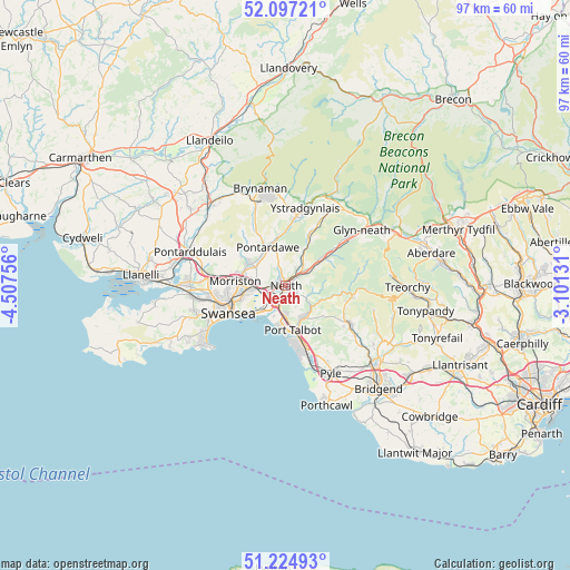
Neath GPS coordinates[2]
51° 39' 47.412" North, 3° 48' 15.948" West
| Map corner | latitude | longitude |
|---|---|---|
| Upper-left | 52.09721°, | -4.50756° |
| Center: | 51.66317°, | -3.80443° |
| Lower-right: | 51.22493°, | -3.10131° |
| Map W x H: | 97×97 km | = 60.3×60.3mi |
| max Lat: | 60.39635° ⇑72.3% North |
| Neath: | 51.66317° |
| min Lat: | ⇓27.7% South 34.60088° |
| min Long | Neath | max Long |
| -7.64133° | -3.80443° | 32.95536° |
| W 14.2%⇐ | ⇒85.8% E |
Elevation
Elevation of Neath is 13 m = 43 ft, and this is 59.9 m = 197 ft below average elevation for this country.
| Max E: |
515 m = 1690 ft | 88.2% |
| Avg. | 72.9 m = 239 ft | |
| Neath | 13 m = 43 ft | |
Min E: |
-30 m = -98 ft | 11.8% |
See also: Neath elevation on elevation.city.
Geographical zone
Neath is located in North temperate zone (between Tropic of Cancer and the Arctic Circle). Distance of this North polar circle is 1656.8 km =1029.5 mi to North.| Distance of | km | miles | from Neath |
|---|---|---|---|
| North Pole | 4262.7 | 2648.7 | to North |
| Arctic Circle | 1656.8 | 1029.5 | to North |
| Tropic Cancer | 3138.5 | 1950.2 | to South |
| Equator | 5744.4 | 3569.4 | to South |


Nearby cities:
15 places around Neath: (largest is in red/bold)
• Briton Ferry
3.7 km =2.3 mi,  195°
195°
• Bryn
8.2 km =5.1 mi,  129°
129°
• Clydach
7 km =4.3 mi,  288°
288°
• Croeserw
11.5 km =7.1 mi,  100°
100°
• Crynant
8.3 km =5.2 mi,  27°
27°
• Cwmafan
5.9 km =3.7 mi,  150°
150°
• Landore
9.7 km =6 mi,  257°
257°
• Maesteg
11.7 km =7.3 mi,  120°
120°
• Morriston
8.7 km =5.4 mi,  274°
274°
• Pontrhydyfen
5.2 km =3.2 mi, 127°
• Port Talbot
8 km =5 mi,  167°
167°
• Resolven
9.2 km =5.7 mi,  53°
53°
• Swansea
10.7 km =6.6 mi,  243°
243°
• Taibach
9.3 km =5.8 mi,  163°
163°
• Ystalyfera
11.7 km =7.3 mi,  8°
8°
Sources, notices
• [Note1] Compared only with cities in United Kingdom existing in our database
• [Src1] Map data: © OpenStreetMap contributors (CC-BY-SA)
• [Src2] Other city data from geonames.org with taken over terms of usage.
• [Src3] Geographical zone / Annual Mean Temperature by Robert A. Rohde @ Wikipedia
