Swansea geodata
Swansea (Wales) is a seat of a second-order administrative division; located in United Kingdom in Europe/London (GMT+1) time zone. With population of 300,352 people, there are 22 cities with bigger population in this country. Compared to other cities in United Kingdom, 73.7% of cities are located further ↑North; 87.5% of cities are located further →East and 82.8% of cities have higher elevation than Swansea. Note1


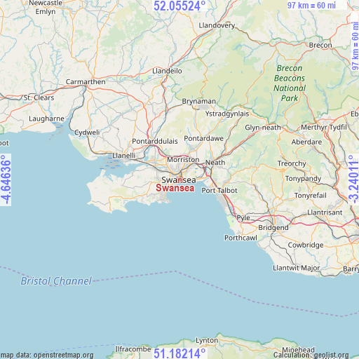
Swansea GPS coordinates[2]
51° 37' 14.844" North, 3° 56' 35.628" West
| Map corner | latitude | longitude |
|---|---|---|
| Upper-left | 52.05524°, | -4.64636° |
| Center: | 51.62079°, | -3.94323° |
| Lower-right: | 51.18214°, | -3.24011° |
| Map W x H: | 97.1×97.1 km | = 60.3×60.3mi |
| max Lat: | 60.39635° ⇑73.7% North |
| Swansea: | 51.62079° |
| min Lat: | ⇓26.3% South 34.60088° |
| min Long | Swansea | max Long |
| -7.64133° | -3.94323° | 32.95536° |
| W 12.5%⇐ | ⇒87.5% E |
Elevation
Elevation of Swansea is 18 m = 59 ft, and this is 54.9 m = 180 ft below average elevation for this country.
| Max E: |
515 m = 1690 ft | 82.8% |
| Avg. | 72.9 m = 239 ft | |
| Swansea | 18 m = 59 ft | |
Min E: |
-30 m = -98 ft | 17.2% |
See also: Swansea elevation on elevation.city.
Geographical zone
Swansea is located in North temperate zone (between Tropic of Cancer and the Arctic Circle). Distance of this North polar circle is 1661.5 km =1032.4 mi to North.| Distance of | km | miles | from Swansea |
|---|---|---|---|
| North Pole | 4267.4 | 2651.6 | to North |
| Arctic Circle | 1661.5 | 1032.4 | to North |
| Tropic Cancer | 3133.8 | 1947.3 | to South |
| Equator | 5739.7 | 3566.5 | to South |


Nearby cities:
15 places around Swansea: (largest is in red/bold)
• Bishopston
8.7 km =5.4 mi,  236°
236°
• Briton Ferry
8.7 km =5.4 mi,  82°
82°
• Clydach
7.6 km =4.7 mi,  23°
23°
• Gorseinon
8.7 km =5.4 mi,  308°
308°
• Grovesend
9.7 km =6 mi,  317°
317°
• Landore
2.6 km =1.6 mi,  2°
2°
• Morriston
5.5 km =3.4 mi,  9°
9°
• Neath
10.7 km =6.6 mi,  63°
63°
• Pen-clawdd
11 km =6.8 mi,  281°
281°
• Pennard
11.1 km =6.9 mi, 243°
• Pontarddulais
12.3 km =7.6 mi,  327°
327°
• Pontlliw
9.1 km =5.7 mi, 329°
• Port Talbot
11.7 km =7.3 mi,  105°
105°
• Southgate
11.6 km =7.2 mi, 240°
• Three Crosses
8.3 km =5.2 mi, 276°
Sources, notices
• [Note1] Compared only with cities in United Kingdom existing in our database
• [Src1] Map data: © OpenStreetMap contributors (CC-BY-SA)
• [Src2] Other city data from geonames.org with taken over terms of usage.
• [Src3] Geographical zone / Annual Mean Temperature by Robert A. Rohde @ Wikipedia
