Saint Stephen geodata
Saint Stephen (England) is a populated place; located in United Kingdom in Europe/London (GMT+1) time zone. With population of 2,252 people, there are 2475 cities with bigger population in this country. Compared to other cities in United Kingdom, 98.9% of cities are located further ↑North; 95.6% of cities are located further →East and 51.1% of cities have lower elevation than Saint Stephen. Note1


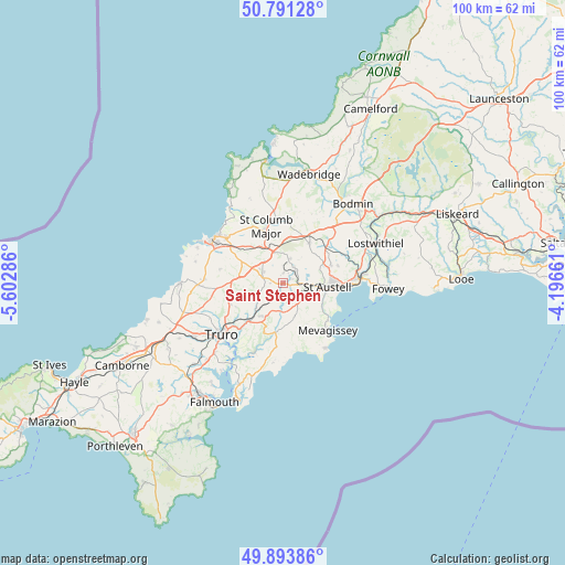
Saint Stephen GPS coordinates[2]
50° 20' 40.884" North, 4° 53' 59.028" West
| Map corner | latitude | longitude |
|---|---|---|
| Upper-left | 50.79128°, | -5.60286° |
| Center: | 50.34469°, | -4.89973° |
| Lower-right: | 49.89386°, | -4.19661° |
| Map W x H: | 99.8×99.8 km | = 62×62mi |
| max Lat: | 60.39635° ⇑98.9% North |
| Saint Stephen: | 50.34469° |
| min Lat: | ⇓1.1% South 34.60088° |
| min Long | Saint Stephen | max Long |
| -7.64133° | -4.89973° | 32.95536° |
| W 4.4%⇐ | ⇒95.6% E |
Elevation
Elevation of Saint Stephen is 62 m = 203 ft, and this is 10.9 m = 36 ft below average elevation for this country.
| Max E: |
515 m = 1690 ft | 48.9% |
| Avg. | 72.9 m = 239 ft | |
| Saint Stephen | 62 m = 203 ft | |
Min E: |
-30 m = -98 ft | 51.1% |
See also: United Kingdom elevation on elevation.city.
Geographical zone
Saint Stephen is located in North temperate zone (between Tropic of Cancer and the Arctic Circle). Distance of this North polar circle is 1803.4 km =1120.6 mi to North.| Distance of | km | miles | from Saint Stephen |
|---|---|---|---|
| North Pole | 4409.3 | 2739.8 | to North |
| Arctic Circle | 1803.4 | 1120.6 | to North |
| Tropic Cancer | 2991.9 | 1859.1 | to South |
| Equator | 5597.8 | 3478.3 | to South |


Nearby cities:
15 places around Saint Stephen: (largest is in red/bold)
• Bugle
9.4 km =5.8 mi,  53°
53°
• Gorran Haven
13.9 km =8.6 mi,  145°
145°
• Grampound
5 km =3.1 mi,  180°
180°
• Lanivet
14.6 km =9.1 mi,  41°
41°
• Mevagissey
11 km =6.8 mi,  135°
135°
• Nanpean
3.4 km =2.1 mi, 38°
• Newquay
14.6 km =9.1 mi,  302°
302°
• Par
14 km =8.7 mi,  87°
87°
• Probus
7 km =4.3 mi,  213°
213°
• Roche
8.5 km =5.3 mi,  33°
33°
• Saint Columb Major
10.1 km =6.3 mi,  342°
342°
• Saint Dennis
4.5 km =2.8 mi,  15°
15°
• St Austell
8.9 km =5.5 mi, 91°
• Tregoney
8.7 km =5.4 mi,  187°
187°
• Truro
14.1 km =8.8 mi,  231°
231°
Sources, notices
• [Note1] Compared only with cities in United Kingdom existing in our database
• [Src1] Map data: © OpenStreetMap contributors (CC-BY-SA)
• [Src2] Other city data from geonames.org with taken over terms of usage.
• [Src3] Geographical zone / Annual Mean Temperature by Robert A. Rohde @ Wikipedia
