Lytchett Matravers geodata
Lytchett Matravers (England) is a populated place; located in United Kingdom in Europe/London (GMT+1) time zone. With population of 3,315 people, there are 2023 cities with bigger population in this country. Compared to other cities in United Kingdom, 95.8% of cities are located further ↑North; 56.2% of cities are located further →East and 65% of cities have lower elevation than Lytchett Matravers. Note1
Administrative division(s):
- Level 1: England
- Level 2: Dorset
- Level 3: Purbeck District
- Level 4: Lytchett Matravers


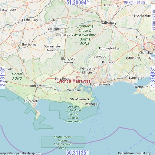
Lytchett Matravers GPS coordinates[2]
50° 45' 29.736" North, 2° 4' 41.016" West
| Map corner | latitude | longitude |
|---|---|---|
| Upper-left | 51.20094°, | -2.78118° |
| Center: | 50.75826°, | -2.07806° |
| Lower-right: | 50.31135°, | -1.37493° |
| Map W x H: | 98.9×98.9 km | = 61.5×61.5mi |
| max Lat: | 60.39635° ⇑95.8% North |
| Lytchett Matravers: | 50.75826° |
| min Lat: | ⇓4.2% South 34.60088° |
| min Long | Lytchett Matrav | max Long |
| -7.64133° | -2.07806° | 32.95536° |
| W 43.8%⇐ | ⇒56.2% E |
Elevation
Elevation of Lytchett Matravers is 86 m = 282 ft, and this is 13.1 m = 43 ft above average elevation for this country.
| Max E: |
515 m = 1690 ft | 35% |
| Lytchett Matravers | 86 m 282 ft | |
| Avg. | 72.9 m = 239 ft | |
Min E: |
-30 m = -98 ft | 65% |
See also: United Kingdom elevation on elevation.city.
Geographical zone
Lytchett Matravers is located in North temperate zone (between Tropic of Cancer and the Arctic Circle). Distance of this North polar circle is 1757.4 km =1092 mi to North.| Distance of | km | miles | from Lytchett Matravers |
|---|---|---|---|
| North Pole | 4363.3 | 2711.2 | to North |
| Arctic Circle | 1757.4 | 1092 | to North |
| Tropic Cancer | 3037.9 | 1887.7 | to South |
| Equator | 5643.8 | 3506.9 | to South |


Nearby cities:
15 places around Lytchett Matravers: (largest is in red/bold)
• Bere Regis
9.7 km =6 mi,  267°
267°
• Blandford Forum
12.8 km =8 mi,  332°
332°
• Bovington Camp
12.9 km =8 mi,  238°
238°
• Broadstone
5.9 km =3.7 mi,  91°
91°
• Canford Heath
7.7 km =4.8 mi,  95°
95°
• Charlton Marshall
9.7 km =6 mi, 332°
• Corfe Castle
13.3 km =8.3 mi,  173°
173°
• Parkstone
9.9 km =6.2 mi,  108°
108°
• Poole
8.2 km =5.1 mi,  126°
126°
• Spetisbury
7.7 km =4.8 mi, 334°
• Sturminster Marshall
4.6 km =2.9 mi,  1°
1°
• Wareham
8.1 km =5 mi,  196°
196°
• Wimborne Minster
7.2 km =4.5 mi,  67°
67°
• Winterborne Kingston
8.7 km =5.4 mi,  284°
284°
• Wool
13.2 km =8.2 mi,  228°
228°
Sources, notices
• [Note1] Compared only with cities in United Kingdom existing in our database
• [Src1] Map data: © OpenStreetMap contributors (CC-BY-SA)
• [Src2] Other city data from geonames.org with taken over terms of usage.
• [Src3] Geographical zone / Annual Mean Temperature by Robert A. Rohde @ Wikipedia
