Broadstone geodata
Broadstone (England) is a populated place; located in United Kingdom in Europe/London (GMT+0) time zone. With population of 10,256 people, there are 1027 cities with bigger population in this country. Compared to other cities in United Kingdom, 95.9% of cities are located further ↑North; 54.6% of cities are located further →East and 59.5% of cities have higher elevation than Broadstone. Note1


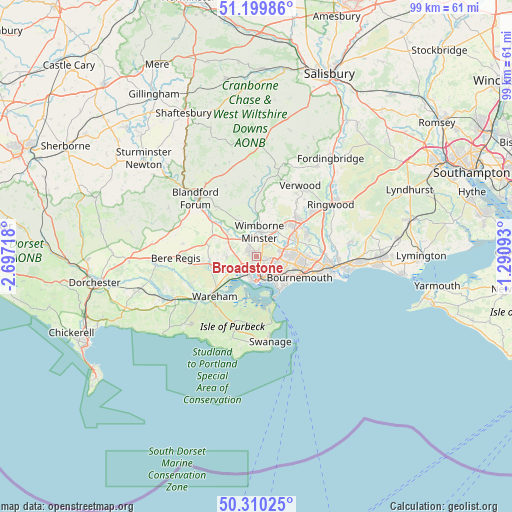
Broadstone GPS coordinates[2]
50° 45' 25.812" North, 1° 59' 38.616" West
| Map corner | latitude | longitude |
|---|---|---|
| Upper-left | 51.19986°, | -2.69718° |
| Center: | 50.75717°, | -1.99406° |
| Lower-right: | 50.31025°, | -1.29093° |
| Map W x H: | 98.9×98.9 km | = 61.5×61.5mi |
| max Lat: | 60.39635° ⇑95.9% North |
| Broadstone: | 50.75717° |
| min Lat: | ⇓4.1% South 34.60088° |
| min Long | Broadstone | max Long |
| -7.64133° | -1.99406° | 32.95536° |
| W 45.4%⇐ | ⇒54.6% E |
Elevation
Elevation of Broadstone is 47 m = 154 ft, and this is 25.9 m = 85 ft below average elevation for this country.
| Max E: |
515 m = 1690 ft | 59.5% |
| Avg. | 72.9 m = 239 ft | |
| Broadstone | 47 m = 154 ft | |
Min E: |
-30 m = -98 ft | 40.5% |
See also: United Kingdom elevation on elevation.city.
Geographical zone
Broadstone is located in North temperate zone (between Tropic of Cancer and the Arctic Circle). Distance of this North polar circle is 1757.5 km =1092.1 mi to North.| Distance of | km | miles | from Broadstone |
|---|---|---|---|
| North Pole | 4363.4 | 2711.3 | to North |
| Arctic Circle | 1757.5 | 1092.1 | to North |
| Tropic Cancer | 3037.7 | 1887.5 | to South |
| Equator | 5643.7 | 3506.8 | to South |


Nearby cities:
15 places around Broadstone: (largest is in red/bold)
• Bournemouth
9 km =5.6 mi,  116°
116°
• Canford Heath
1.9 km =1.2 mi,  110°
110°
• Charlton Marshall
13.6 km =8.5 mi,  310°
310°
• Corfe Castle
13.8 km =8.6 mi,  198°
198°
• Ferndown
8.7 km =5.4 mi,  49°
49°
• Lytchett Matravers
5.9 km =3.7 mi,  271°
271°
• Parkstone
4.6 km =2.9 mi,  131°
131°
• Poole
4.8 km =3 mi,  172°
172°
• Spetisbury
11.6 km =7.2 mi, 307°
• St Leonards
13.4 km =8.3 mi, 52°
• Sturminster Marshall
7.5 km =4.7 mi, 309°
• Three Legged Cross
12.9 km =8 mi,  37°
37°
• Wareham
11.2 km =7 mi,  226°
226°
• Wimborne Minster
3 km =1.9 mi,  14°
14°
• Winterborne Kingston
14.5 km =9 mi,  279°
279°
Sources, notices
• [Note1] Compared only with cities in United Kingdom existing in our database
• [Src1] Map data: © OpenStreetMap contributors (CC-BY-SA)
• [Src2] Other city data from geonames.org with taken over terms of usage.
• [Src3] Geographical zone / Annual Mean Temperature by Robert A. Rohde @ Wikipedia
