Poole geodata
Poole (England) is a seat of a second-order administrative division; located in United Kingdom in Europe/London (GMT+1) time zone. With population of 150,092 people, there are 58 cities with bigger population in this country. Compared to other cities in United Kingdom, 96.4% of cities are located further ↑North; 54.5% of cities are located further →East and 97.5% of cities have higher elevation than Poole. Note1


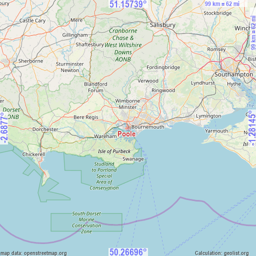
Poole GPS coordinates[2]
50° 42' 51.444" North, 1° 59' 4.488" West
| Map corner | latitude | longitude |
|---|---|---|
| Upper-left | 51.15739°, | -2.6877° |
| Center: | 50.71429°, | -1.98458° |
| Lower-right: | 50.26696°, | -1.28145° |
| Map W x H: | 99×99 km | = 61.5×61.5mi |
| max Lat: | 60.39635° ⇑96.4% North |
| Poole: | 50.71429° |
| min Lat: | ⇓3.6% South 34.60088° |
| min Long | Poole | max Long |
| -7.64133° | -1.98458° | 32.95536° |
| W 45.5%⇐ | ⇒54.5% E |
Elevation
Elevation of Poole is 6 m = 20 ft, and this is 66.9 m = 219 ft below average elevation for this country.
| Max E: |
515 m = 1690 ft | 97.5% |
| Avg. | 72.9 m = 239 ft | |
| Poole | 6 m = 20 ft | |
Min E: |
-30 m = -98 ft | 2.5% |
See also: Poole elevation on elevation.city.
Geographical zone
Poole is located in North temperate zone (between Tropic of Cancer and the Arctic Circle). Distance of this North polar circle is 1762.3 km =1095 mi to North.| Distance of | km | miles | from Poole |
|---|---|---|---|
| North Pole | 4368.2 | 2714.3 | to North |
| Arctic Circle | 1762.3 | 1095 | to North |
| Tropic Cancer | 3033 | 1884.6 | to South |
| Equator | 5638.9 | 3503.8 | to South |


Nearby cities:
15 places around Poole: (largest is in red/bold)
• Bournemouth
7.4 km =4.6 mi,  84°
84°
• Broadstone
4.8 km =3 mi,  352°
352°
• Canford Heath
4.2 km =2.6 mi,  15°
15°
• Christchurch
14.5 km =9 mi, 80°
• Corfe Castle
9.7 km =6 mi,  211°
211°
• Ferndown
12 km =7.5 mi,  29°
29°
• Lytchett Matravers
8.2 km =5.1 mi,  306°
306°
• Parkstone
3.3 km =2.1 mi,  58°
58°
• Spetisbury
15.4 km =9.6 mi,  320°
320°
• St Leonards
16.3 km =10.1 mi,  37°
37°
• Sturminster Marshall
11.5 km =7.1 mi,  325°
325°
• Swanage
11.8 km =7.3 mi,  172°
172°
• Wareham
9.3 km =5.8 mi,  251°
251°
• Wimborne Minster
7.7 km =4.8 mi,  0°
0°
• Winterborne Kingston
16.6 km =10.3 mi,  295°
295°
Sources, notices
• [Note1] Compared only with cities in United Kingdom existing in our database
• [Src1] Map data: © OpenStreetMap contributors (CC-BY-SA)
• [Src2] Other city data from geonames.org with taken over terms of usage.
• [Src3] Geographical zone / Annual Mean Temperature by Robert A. Rohde @ Wikipedia
