Lowestoft geodata
Lowestoft (England) is a populated place; located in United Kingdom in Europe/London (GMT+1) time zone. With population of 70,945 people, there are 150 cities with bigger population in this country. Compared to other cities in United Kingdom, 50.4% of cities are located further ↑North; 100% of cities are located further ←West and 99.9% of cities have higher elevation than Lowestoft. Note1


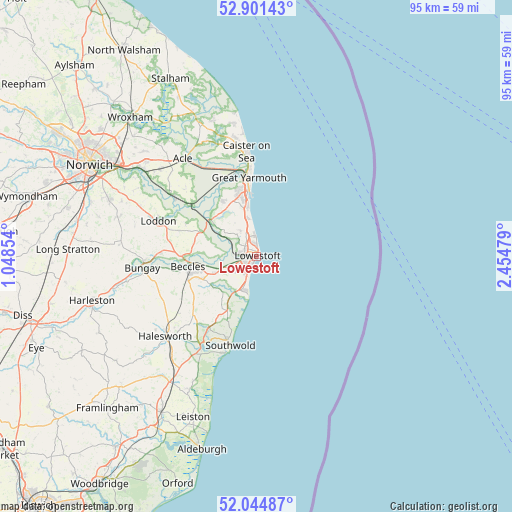
Lowestoft GPS coordinates[2]
52° 28' 30.828" North, 1° 45' 6.012" East
| Map corner | latitude | longitude |
|---|---|---|
| Upper-left | 52.90143°, | 1.04854° |
| Center: | 52.47523°, | 1.75167° |
| Lower-right: | 52.04487°, | 2.45479° |
| Map W x H: | 95.2×95.2 km | = 59.2×59.2mi |
| max Lat: | 60.39635° ⇑50.4% North |
| Lowestoft: | 52.47523° |
| min Lat: | ⇓49.6% South 34.60088° |
| min Long | Lowestoft | max Long |
| -7.64133° | 1.75167° | 32.95536° |
| W 100%⇐ | ⇒0% E |
Elevation
Elevation of Lowestoft is 1 m = 3 ft, and this is 71.9 m = 236 ft below average elevation for this country.
| Max E: |
515 m = 1690 ft | 99.9% |
| Avg. | 72.9 m = 239 ft | |
| Lowestoft | 1 m = 3 ft | |
Min E: |
-30 m = -98 ft | 0.1% |
See also: Lowestoft elevation on elevation.city.
Geographical zone
Lowestoft is located in North temperate zone (between Tropic of Cancer and the Arctic Circle). Distance of this North polar circle is 1566.5 km =973.4 mi to North.| Distance of | km | miles | from Lowestoft |
|---|---|---|---|
| North Pole | 4172.4 | 2592.6 | to North |
| Arctic Circle | 1566.5 | 973.4 | to North |
| Tropic Cancer | 3228.8 | 2006.3 | to South |
| Equator | 5834.7 | 3625.5 | to South |


Nearby cities:
15 places around Lowestoft: (largest is in red/bold)
• Barnby
8 km =5 mi,  248°
248°
• Beccles
12.8 km =8 mi,  262°
262°
• Bradwell
11.5 km =7.1 mi,  342°
342°
• Ellingham
17.8 km =11.1 mi,  272°
272°
• Freethorpe
18.6 km =11.6 mi,  314°
314°
• Gorleston-on-Sea
11 km =6.8 mi,  352°
352°
• Great Yarmouth
14.9 km =9.3 mi, 354°
• Hales
17.3 km =10.7 mi,  287°
287°
• Halvergate
18.8 km =11.7 mi,  320°
320°
• Hopton on Sea
6.6 km =4.1 mi, 349°
• Kessingland
6.8 km =4.2 mi,  205°
205°
• Reedham
15.5 km =9.6 mi, 307°
• Southwold
17.2 km =10.7 mi,  196°
196°
• Thurlton
14.5 km =9 mi, 294°
• Wrentham
11.7 km =7.3 mi, 209°
Sources, notices
• [Note1] Compared only with cities in United Kingdom existing in our database
• [Src1] Map data: © OpenStreetMap contributors (CC-BY-SA)
• [Src2] Other city data from geonames.org with taken over terms of usage.
• [Src3] Geographical zone / Annual Mean Temperature by Robert A. Rohde @ Wikipedia
