Kessingland geodata
Kessingland (England) is a populated place; located in United Kingdom in Europe/London (GMT+1) time zone. With population of 4,327 people, there are 1770 cities with bigger population in this country. Compared to other cities in United Kingdom, 51.3% of cities are located further ↑North; 99.9% of cities are located further ←West and 79.9% of cities have higher elevation than Kessingland. Note1
Administrative division(s):
- Level 1: England
- Level 2: Suffolk
- Level 3: Waveney District
- Level 4: Kessingland


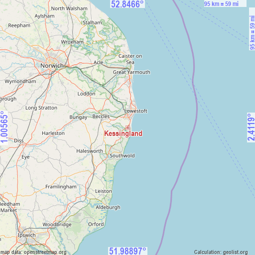
Kessingland GPS coordinates[2]
52° 25' 11.532" North, 1° 42' 31.608" East
| Map corner | latitude | longitude |
|---|---|---|
| Upper-left | 52.8466°, | 1.00565° |
| Center: | 52.41987°, | 1.70878° |
| Lower-right: | 51.98897°, | 2.4119° |
| Map W x H: | 95.4×95.4 km | = 59.3×59.3mi |
| max Lat: | 60.39635° ⇑51.3% North |
| Kessingland: | 52.41987° |
| min Lat: | ⇓48.7% South 34.60088° |
| min Long | Kessingland | max Long |
| -7.64133° | 1.70878° | 32.95536° |
| W 99.9%⇐ | ⇒0.099999999999994% E |
Elevation
Elevation of Kessingland is 21 m = 69 ft, and this is 51.9 m = 170 ft below average elevation for this country.
| Max E: |
515 m = 1690 ft | 79.9% |
| Avg. | 72.9 m = 239 ft | |
| Kessingland | 21 m = 69 ft | |
Min E: |
-30 m = -98 ft | 20.1% |
See also: United Kingdom elevation on elevation.city.
Geographical zone
Kessingland is located in North temperate zone (between Tropic of Cancer and the Arctic Circle). Distance of this North polar circle is 1572.6 km =977.2 mi to North.| Distance of | km | miles | from Kessingland |
|---|---|---|---|
| North Pole | 4178.5 | 2596.4 | to North |
| Arctic Circle | 1572.6 | 977.2 | to North |
| Tropic Cancer | 3222.6 | 2002.4 | to South |
| Equator | 5828.5 | 3621.7 | to South |


Nearby cities:
15 places around Kessingland: (largest is in red/bold)
• Barnby
5.5 km =3.4 mi,  304°
304°
• Beccles
10.7 km =6.6 mi,  294°
294°
• Bradwell
17.1 km =10.6 mi,  357°
357°
• Bungay
18.7 km =11.6 mi,  281°
281°
• Ditchingham
18.7 km =11.6 mi, 286°
• Ellingham
16.4 km =10.2 mi, 294°
• Gorleston-on-Sea
17.1 km =10.6 mi,  4°
4°
• Hales
17.7 km =11 mi,  310°
310°
• Halesworth
16.2 km =10.1 mi,  239°
239°
• Hopton on Sea
12.7 km =7.9 mi,  7°
7°
• Lowestoft
6.8 km =4.2 mi,  25°
25°
• Reedham
18.2 km =11.3 mi,  329°
329°
• Southwold
10.5 km =6.5 mi,  190°
190°
• Thurlton
15.9 km =9.9 mi,  319°
319°
• Wrentham
4.9 km =3 mi,  215°
215°
Sources, notices
• [Note1] Compared only with cities in United Kingdom existing in our database
• [Src1] Map data: © OpenStreetMap contributors (CC-BY-SA)
• [Src2] Other city data from geonames.org with taken over terms of usage.
• [Src3] Geographical zone / Annual Mean Temperature by Robert A. Rohde @ Wikipedia
