Longhorsley geodata
Longhorsley (England) is a seat of a third-order administrative division; located in United Kingdom in Europe/London (GMT+0) time zone. With population of 887 people, there are 3835 cities with bigger population in this country. Compared to other cities in United Kingdom, 87.9% of cities are located further ↓South; 50.5% of cities are located further →East and 81.6% of cities have lower elevation than Longhorsley. Note1


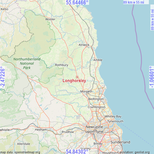
Longhorsley GPS coordinates[2]
55° 14' 45.096" North, 1° 46' 8.904" West
| Map corner | latitude | longitude |
|---|---|---|
| Upper-left | 55.64466°, | -2.47226° |
| Center: | 55.24586°, | -1.76914° |
| Lower-right: | 54.84302°, | -1.06601° |
| Map W x H: | 89.1×89.1 km | = 55.4×55.4mi |
| max Lat: | 60.39635° ⇑12.1% North |
| Longhorsley: | 55.24586° |
| min Lat: | ⇓87.9% South 34.60088° |
| min Long | Longhorsley | max Long |
| -7.64133° | -1.76914° | 32.95536° |
| W 49.5%⇐ | ⇒50.5% E |
Elevation
Elevation of Longhorsley is 122 m = 400 ft, and this is 49.1 m = 161 ft above average elevation for this country.
| Max E: |
515 m = 1690 ft | 18.4% |
| Longhorsley | 122 m 400 ft | |
| Avg. | 72.9 m = 239 ft | |
Min E: |
-30 m = -98 ft | 81.6% |
See also: United Kingdom elevation on elevation.city.
Geographical zone
Longhorsley is located in North temperate zone (between Tropic of Cancer and the Arctic Circle). Distance of this North polar circle is 1258.4 km =781.9 mi to North.| Distance of | km | miles | from Longhorsley |
|---|---|---|---|
| North Pole | 3864.3 | 2401.2 | to North |
| Arctic Circle | 1258.4 | 781.9 | to North |
| Tropic Cancer | 3536.8 | 2197.7 | to South |
| Equator | 6142.8 | 3817 | to South |


Nearby cities:
15 places around Longhorsley: (largest is in red/bold)
• Acklington
10.5 km =6.5 mi,  55°
55°
• Cresswell
14.3 km =8.9 mi,  103°
103°
• East Chevington
12.5 km =7.8 mi,  70°
70°
• Felton
6.8 km =4.2 mi,  32°
32°
• Hadston
11.8 km =7.3 mi, 62°
• Hartburn
10.2 km =6.3 mi,  210°
210°
• Hebron
8.8 km =5.5 mi,  141°
141°
• Longframlington
6.7 km =4.2 mi,  345°
345°
• Meldon
12.7 km =7.9 mi,  188°
188°
• Morpeth
10 km =6.2 mi,  149°
149°
• Pegswood
10.8 km =6.7 mi,  133°
133°
• Rothbury
11.4 km =7.1 mi,  309°
309°
• Rothley
11.7 km =7.3 mi,  233°
233°
• Shilbottle
14.8 km =9.2 mi,  20°
20°
• Swarland
8.8 km =5.5 mi,  10°
10°
Sources, notices
• [Note1] Compared only with cities in United Kingdom existing in our database
• [Src1] Map data: © OpenStreetMap contributors (CC-BY-SA)
• [Src2] Other city data from geonames.org with taken over terms of usage.
• [Src3] Geographical zone / Annual Mean Temperature by Robert A. Rohde @ Wikipedia
