Hartburn geodata
Hartburn (England) is a seat of a third-order administrative division; located in United Kingdom in Europe/London (GMT+0) time zone. In our database, there are 4977 cities with bigger population. Compared to other cities in United Kingdom, 87.5% of cities are located further ↓South; 52% of cities are located further →East and 83.8% of cities have lower elevation than Hartburn. Note1


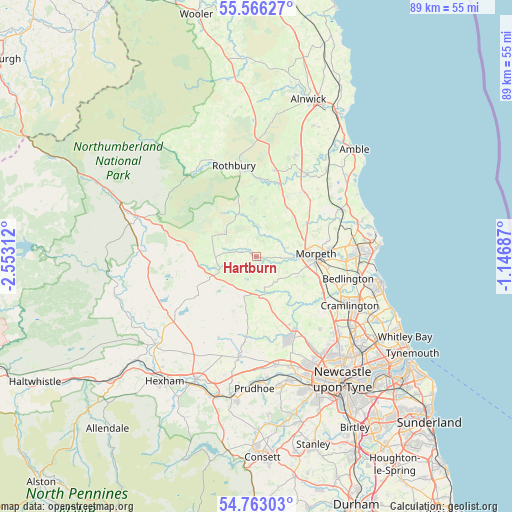
Hartburn GPS coordinates[2]
55° 10' 0.012" North, 1° 51' 0" West
| Map corner | latitude | longitude |
|---|---|---|
| Upper-left | 55.56627°, | -2.55312° |
| Center: | 55.16667°, | -1.85° |
| Lower-right: | 54.76303°, | -1.14687° |
| Map W x H: | 89.3×89.3 km | = 55.5×55.5mi |
| max Lat: | 60.39635° ⇑12.5% North |
| Hartburn: | 55.16667° |
| min Lat: | ⇓87.5% South 34.60088° |
| min Long | Hartburn | max Long |
| -7.64133° | -1.85° | 32.95536° |
| W 48%⇐ | ⇒52% E |
Elevation
Elevation of Hartburn is 129 m = 423 ft, and this is 56.1 m = 184 ft above average elevation for this country.
| Max E: |
515 m = 1690 ft | 16.2% |
| Hartburn | 129 m 423 ft | |
| Avg. | 72.9 m = 239 ft | |
Min E: |
-30 m = -98 ft | 83.8% |
See also: United Kingdom elevation on elevation.city.
Geographical zone
Hartburn is located in North temperate zone (between Tropic of Cancer and the Arctic Circle). Distance of this North polar circle is 1267.2 km =787.4 mi to North.| Distance of | km | miles | from Hartburn |
|---|---|---|---|
| North Pole | 3873.1 | 2406.6 | to North |
| Arctic Circle | 1267.2 | 787.4 | to North |
| Tropic Cancer | 3528 | 2192.2 | to South |
| Equator | 6134 | 3811.5 | to South |


Nearby cities:
15 places around Hartburn: (largest is in red/bold)
• Bedlington
16.8 km =10.4 mi,  103°
103°
• Choppington
15.8 km =9.8 mi, 96°
• Darras Hall
15.6 km =9.7 mi,  159°
159°
• Dinnington
16.7 km =10.4 mi,  138°
138°
• Felton
17 km =10.6 mi,  31°
31°
• Hebron
10.7 km =6.6 mi,  80°
80°
• Longframlington
15.7 km =9.8 mi,  12°
12°
• Longhorsley
10.2 km =6.3 mi, 30°
• Meldon
4.9 km =3 mi, 139°
• Morpeth
10.2 km =6.3 mi,  88°
88°
• Pegswood
13.1 km =8.1 mi, 83°
• Ponteland
14.6 km =9.1 mi,  152°
152°
• Rothbury
16.4 km =10.2 mi,  346°
346°
• Rothley
4.6 km =2.9 mi,  293°
293°
• Stannington
13.2 km =8.2 mi,  119°
119°
Sources, notices
• [Note1] Compared only with cities in United Kingdom existing in our database
• [Src1] Map data: © OpenStreetMap contributors (CC-BY-SA)
• [Src2] Other city data from geonames.org with taken over terms of usage.
• [Src3] Geographical zone / Annual Mean Temperature by Robert A. Rohde @ Wikipedia
