Derry geodata
Derry (Northern Ireland) is a seat of a second-order administrative division; located in United Kingdom in Europe/London (GMT+1) time zone. With population of 83,652 people, there are 121 cities with bigger population in this country. Compared to other cities in United Kingdom, 86.7% of cities are located further ↓South; 99.7% of cities are located further →East and 77.1% of cities have higher elevation than Derry. Note1


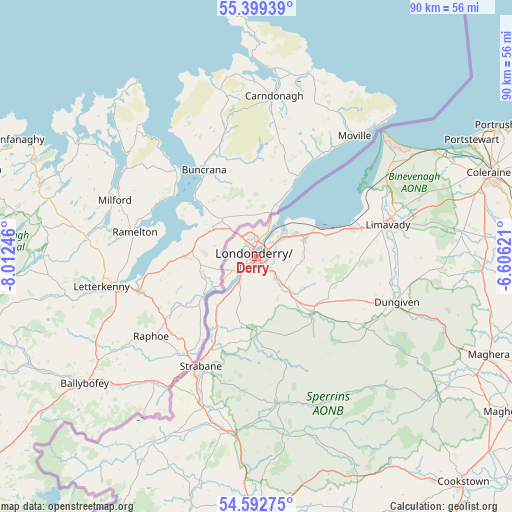
Derry GPS coordinates[2]
54° 59' 53.16" North, 7° 18' 33.624" West
| Map corner | latitude | longitude |
|---|---|---|
| Upper-left | 55.39939°, | -8.01246° |
| Center: | 54.9981°, | -7.30934° |
| Lower-right: | 54.59275°, | -6.60621° |
| Map W x H: | 89.7×89.7 km | = 55.7×55.7mi |
| max Lat: | 60.39635° ⇑13.3% North |
| Derry: | 54.9981° |
| min Lat: | ⇓86.7% South 34.60088° |
| min Long | Derry | max Long |
| -7.64133° | -7.30934° | 32.95536° |
| W 0.3%⇐ | ⇒99.7% E |
Elevation
Elevation of Derry is 24 m = 79 ft, and this is 48.9 m = 160 ft below average elevation for this country.
| Max E: |
515 m = 1690 ft | 77.1% |
| Avg. | 72.9 m = 239 ft | |
| Derry | 24 m = 79 ft | |
Min E: |
-30 m = -98 ft | 22.9% |
See also: Derry elevation on elevation.city.
Geographical zone
Derry is located in North temperate zone (between Tropic of Cancer and the Arctic Circle). Distance of this North polar circle is 1286 km =799.1 mi to North.| Distance of | km | miles | from Derry |
|---|---|---|---|
| North Pole | 3891.8 | 2418.3 | to North |
| Arctic Circle | 1286 | 799.1 | to North |
| Tropic Cancer | 3509.3 | 2180.6 | to South |
| Equator | 6115.2 | 3799.8 | to South |


Nearby cities:
15 places around Derry: (largest is in red/bold)
• Ballykelly
19.2 km =11.9 mi,  74°
74°
• Castlederg
37.1 km =23.1 mi,  209°
209°
• Castlerock
37.5 km =23.3 mi,  63°
63°
• Coleraine
43.6 km =27.1 mi, 69°
• Culmore
6.4 km =4 mi,  25°
25°
• Draperstown
41.1 km =25.5 mi,  122°
122°
• Dungiven
26.1 km =16.2 mi,  106°
106°
• Eglinton
8.3 km =5.2 mi,  75°
75°
• Garvagh
41 km =25.5 mi,  92°
92°
• Limavady
23.6 km =14.7 mi, 75°
• Londonderry County Borough
0.1 km =0.1 mi,  173°
173°
• Newtownstewart
31.5 km =19.6 mi,  188°
188°
• Portstewart
43 km =26.7 mi, 61°
• Sion Mills
25.6 km =15.9 mi,  204°
204°
• Strabane
21.9 km =13.6 mi, 207°
Sources, notices
• [Note1] Compared only with cities in United Kingdom existing in our database
• [Src1] Map data: © OpenStreetMap contributors (CC-BY-SA)
• [Src2] Other city data from geonames.org with taken over terms of usage.
• [Src3] Geographical zone / Annual Mean Temperature by Robert A. Rohde @ Wikipedia
