Llansadwrn geodata
Llansadwrn (Wales) is a seat of a third-order administrative division; located in United Kingdom in Europe/London (GMT+1) time zone. In our database, there are 4977 cities with bigger population. Compared to other cities in United Kingdom, 63.5% of cities are located further ↑North; 86.9% of cities are located further →East and 54.4% of cities have higher elevation than Llansadwrn. Note1


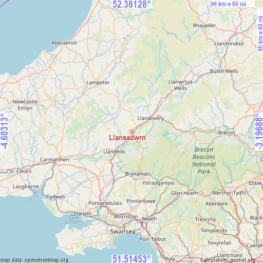
Llansadwrn GPS coordinates[2]
51° 57' 0" North, 3° 54' 0" West
| Map corner | latitude | longitude |
|---|---|---|
| Upper-left | 52.38128°, | -4.60313° |
| Center: | 51.95°, | -3.9° |
| Lower-right: | 51.51453°, | -3.19688° |
| Map W x H: | 96.4×96.4 km | = 59.9×59.9mi |
| max Lat: | 60.39635° ⇑63.5% North |
| Llansadwrn: | 51.95° |
| min Lat: | ⇓36.5% South 34.60088° |
| min Long | Llansadwrn | max Long |
| -7.64133° | -3.9° | 32.95536° |
| W 13.1%⇐ | ⇒86.9% E |
Elevation
Elevation of Llansadwrn is 54 m = 177 ft, and this is 18.9 m = 62 ft below average elevation for this country.
| Max E: |
515 m = 1690 ft | 54.4% |
| Avg. | 72.9 m = 239 ft | |
| Llansadwrn | 54 m = 177 ft | |
Min E: |
-30 m = -98 ft | 45.6% |
See also: United Kingdom elevation on elevation.city.
Geographical zone
Llansadwrn is located in North temperate zone (between Tropic of Cancer and the Arctic Circle). Distance of this North polar circle is 1624.9 km =1009.7 mi to North.| Distance of | km | miles | from Llansadwrn |
|---|---|---|---|
| North Pole | 4230.8 | 2628.9 | to North |
| Arctic Circle | 1624.9 | 1009.7 | to North |
| Tropic Cancer | 3170.4 | 1970 | to South |
| Equator | 5776.3 | 3589.2 | to South |


Nearby cities:
15 places around Llansadwrn: (largest is in red/bold)
• Ammanford
18.5 km =11.5 mi,  199°
199°
• Brynamman
16.8 km =10.4 mi,  172°
172°
• Cray
20.2 km =12.6 mi,  105°
105°
• Cross Hands
21.7 km =13.5 mi,  216°
216°
• Cwmann
20.3 km =12.6 mi,  326°
326°
• Glanamman
16.8 km =10.4 mi,  187°
187°
• Llanddeusant
9.7 km =6 mi,  124°
124°
• Llandeilo
9.6 km =6 mi, 220°
• Llandovery
8.6 km =5.3 mi,  55°
55°
• Llandybie
16.2 km =10.1 mi,  207°
207°
• Llanfynydd
13.9 km =8.6 mi,  259°
259°
• Llangadog
1.8 km =1.1 mi,  138°
138°
• Llangathen
13.3 km =8.3 mi,  233°
233°
• Llansawel
9.7 km =6 mi,  304°
304°
• Tycroes
20.8 km =12.9 mi, 203°
Sources, notices
• [Note1] Compared only with cities in United Kingdom existing in our database
• [Src1] Map data: © OpenStreetMap contributors (CC-BY-SA)
• [Src2] Other city data from geonames.org with taken over terms of usage.
• [Src3] Geographical zone / Annual Mean Temperature by Robert A. Rohde @ Wikipedia
