Llanfair geodata
Llanfair (Wales) is a seat of a third-order administrative division; located in United Kingdom in Europe/London (GMT+1) time zone. In our database, there are 4977 cities with bigger population. Compared to other cities in United Kingdom, 58.1% of cities are located further ↓South; 89.6% of cities are located further →East and 61.1% of cities have lower elevation than Llanfair. Note1


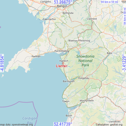
Llanfair GPS coordinates[2]
52° 50' 38.94" North, 4° 6' 55.476" West
| Map corner | latitude | longitude |
|---|---|---|
| Upper-left | 53.26675°, | -4.81854° |
| Center: | 52.84415°, | -4.11541° |
| Lower-right: | 52.41739°, | -3.41229° |
| Map W x H: | 94.4×94.4 km | = 58.7×58.7mi |
| max Lat: | 60.39635° ⇑41.9% North |
| Llanfair: | 52.84415° |
| min Lat: | ⇓58.1% South 34.60088° |
| min Long | Llanfair | max Long |
| -7.64133° | -4.11541° | 32.95536° |
| W 10.4%⇐ | ⇒89.6% E |
Elevation
Elevation of Llanfair is 78 m = 256 ft, and this is 5.1 m = 17 ft above average elevation for this country.
| Max E: |
515 m = 1690 ft | 38.9% |
| Llanfair | 78 m 256 ft | |
| Avg. | 72.9 m = 239 ft | |
Min E: |
-30 m = -98 ft | 61.1% |
See also: United Kingdom elevation on elevation.city.
Geographical zone
Llanfair is located in North temperate zone (between Tropic of Cancer and the Arctic Circle). Distance of this North polar circle is 1525.5 km =947.9 mi to North.| Distance of | km | miles | from Llanfair |
|---|---|---|---|
| North Pole | 4131.3 | 2567.1 | to North |
| Arctic Circle | 1525.5 | 947.9 | to North |
| Tropic Cancer | 3269.8 | 2031.8 | to South |
| Equator | 5875.7 | 3651 | to South |


Nearby cities:
15 places around Llanfair: (largest is in red/bold)
• Barmouth
13.9 km =8.6 mi,  163°
163°
• Chwilog
16.8 km =10.4 mi,  300°
300°
• Criccieth
11.7 km =7.3 mi,  316°
316°
• Dolgellau
19.1 km =11.9 mi,  126°
126°
• Dyffryn Ardudwy
8.2 km =5.1 mi, 155°
• Fairbourne
16.9 km =10.5 mi,  166°
166°
• Ffestiniog
17.8 km =11.1 mi,  43°
43°
• Harlech
1.8 km =1.1 mi,  15°
15°
• Llan Ffestiniog
17.7 km =11 mi, 44°
• Llanbedr
3.2 km =2 mi, 161°
• Maentwrog
14.2 km =8.8 mi, 37°
• Penrhyndeudraeth
10.4 km =6.5 mi, 18°
• Porthmadog
9.5 km =5.9 mi,  353°
353°
• Tal-y-bont
7.9 km =4.9 mi, 168°
• Trawsfynydd
14.4 km =8.9 mi,  63°
63°
Sources, notices
• [Note1] Compared only with cities in United Kingdom existing in our database
• [Src1] Map data: © OpenStreetMap contributors (CC-BY-SA)
• [Src2] Other city data from geonames.org with taken over terms of usage.
• [Src3] Geographical zone / Annual Mean Temperature by Robert A. Rohde @ Wikipedia
