Tal-y-bont geodata
Tal-y-bont (Wales) is a populated place; located in United Kingdom in Europe/London (GMT+1) time zone. With population of 1,540 people, there are 3003 cities with bigger population in this country. Compared to other cities in United Kingdom, 56.9% of cities are located further ↓South; 89.3% of cities are located further →East and 66.8% of cities have higher elevation than Tal-y-bont. Note1


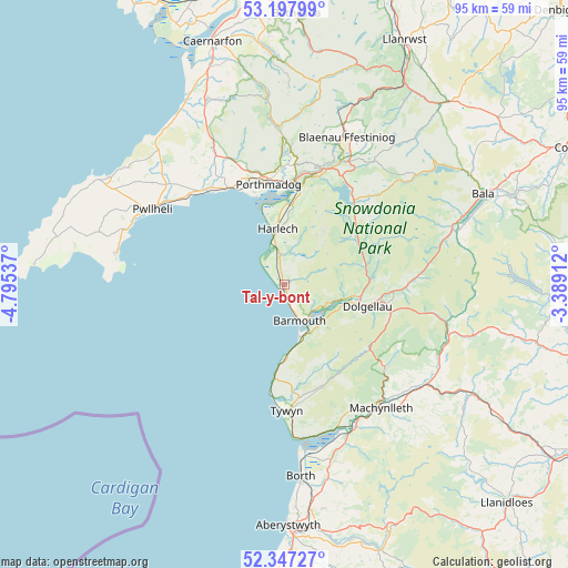
Tal-y-bont GPS coordinates[2]
52° 46' 28.956" North, 4° 5' 32.064" West
| Map corner | latitude | longitude |
|---|---|---|
| Upper-left | 53.19799°, | -4.79537° |
| Center: | 52.77471°, | -4.09224° |
| Lower-right: | 52.34727°, | -3.38912° |
| Map W x H: | 94.6×94.6 km | = 58.8×58.8mi |
| max Lat: | 60.39635° ⇑43.1% North |
| Tal-y-bont: | 52.77471° |
| min Lat: | ⇓56.9% South 34.60088° |
| min Long | Tal-y-bont | max Long |
| -7.64133° | -4.09224° | 32.95536° |
| W 10.7%⇐ | ⇒89.3% E |
Elevation
Elevation of Tal-y-bont is 37 m = 121 ft, and this is 35.9 m = 118 ft below average elevation for this country.
| Max E: |
515 m = 1690 ft | 66.8% |
| Avg. | 72.9 m = 239 ft | |
| Tal-y-bont | 37 m = 121 ft | |
Min E: |
-30 m = -98 ft | 33.2% |
See also: United Kingdom elevation on elevation.city.
Geographical zone
Tal-y-bont is located in North temperate zone (between Tropic of Cancer and the Arctic Circle). Distance of this North polar circle is 1533.2 km =952.7 mi to North.| Distance of | km | miles | from Tal-y-bont |
|---|---|---|---|
| North Pole | 4139.1 | 2571.9 | to North |
| Arctic Circle | 1533.2 | 952.7 | to North |
| Tropic Cancer | 3262.1 | 2027 | to South |
| Equator | 5868 | 3646.2 | to South |


Nearby cities:
15 places around Tal-y-bont: (largest is in red/bold)
• Barmouth
6.1 km =3.8 mi,  157°
157°
• Corris
21.7 km =13.5 mi,  129°
129°
• Criccieth
18.8 km =11.7 mi,  329°
329°
• Dolgellau
14.3 km =8.9 mi,  104°
104°
• Dyffryn Ardudwy
1.9 km =1.2 mi,  80°
80°
• Fairbourne
9 km =5.6 mi, 164°
• Harlech
9.5 km =5.9 mi,  353°
353°
• Llanbedr
4.7 km =2.9 mi, 353°
• Llanfair
7.9 km =4.9 mi, 348°
• Llwyngwril
11.9 km =7.4 mi,  177°
177°
• Maentwrog
20.3 km =12.6 mi,  20°
20°
• Penrhyndeudraeth
17.7 km =11 mi,  5°
5°
• Porthmadog
17.4 km =10.8 mi, 351°
• Trawsfynydd
18.2 km =11.3 mi,  38°
38°
• Tywyn
21 km =13 mi, 180°
Sources, notices
• [Note1] Compared only with cities in United Kingdom existing in our database
• [Src1] Map data: © OpenStreetMap contributors (CC-BY-SA)
• [Src2] Other city data from geonames.org with taken over terms of usage.
• [Src3] Geographical zone / Annual Mean Temperature by Robert A. Rohde @ Wikipedia
