Dolgellau geodata
Dolgellau (Wales) is a populated place; located in United Kingdom in Europe/London (GMT+1) time zone. With population of 2,688 people, there are 2240 cities with bigger population in this country. Compared to other cities in United Kingdom, 56.2% of cities are located further ↓South; 86.7% of cities are located further →East and 88.2% of cities have higher elevation than Dolgellau. Note1


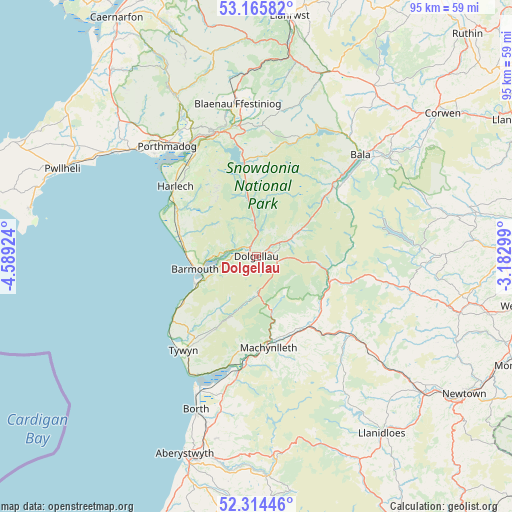
Dolgellau GPS coordinates[2]
52° 44' 31.992" North, 3° 53' 9.996" West
| Map corner | latitude | longitude |
|---|---|---|
| Upper-left | 53.16582°, | -4.58924° |
| Center: | 52.74222°, | -3.88611° |
| Lower-right: | 52.31446°, | -3.18299° |
| Map W x H: | 94.7×94.7 km | = 58.8×58.8mi |
| max Lat: | 60.39635° ⇑43.8% North |
| Dolgellau: | 52.74222° |
| min Lat: | ⇓56.2% South 34.60088° |
| min Long | Dolgellau | max Long |
| -7.64133° | -3.88611° | 32.95536° |
| W 13.3%⇐ | ⇒86.7% E |
Elevation
Elevation of Dolgellau is 13 m = 43 ft, and this is 59.9 m = 197 ft below average elevation for this country.
| Max E: |
515 m = 1690 ft | 88.2% |
| Avg. | 72.9 m = 239 ft | |
| Dolgellau | 13 m = 43 ft | |
Min E: |
-30 m = -98 ft | 11.8% |
See also: United Kingdom elevation on elevation.city.
Geographical zone
Dolgellau is located in North temperate zone (between Tropic of Cancer and the Arctic Circle). Distance of this North polar circle is 1536.8 km =954.9 mi to North.| Distance of | km | miles | from Dolgellau |
|---|---|---|---|
| North Pole | 4142.7 | 2574.2 | to North |
| Arctic Circle | 1536.8 | 954.9 | to North |
| Tropic Cancer | 3258.5 | 2024.7 | to South |
| Equator | 5864.4 | 3644 | to South |


Nearby cities:
15 places around Dolgellau: (largest is in red/bold)
• Barmouth
11.7 km =7.3 mi,  259°
259°
• Corris
10.5 km =6.5 mi,  163°
163°
• Dyffryn Ardudwy
12.6 km =7.8 mi,  288°
288°
• Fairbourne
12.5 km =7.8 mi,  246°
246°
• Ffestiniog
24.4 km =15.2 mi,  352°
352°
• Harlech
19.8 km =12.3 mi,  311°
311°
• Llan Ffestiniog
24.1 km =15 mi, 352°
• Llanbedr
16.6 km =10.3 mi,  299°
299°
• Llanfair
19.1 km =11.9 mi, 306°
• Llwyngwril
15.7 km =9.8 mi,  238°
238°
• Machynlleth
17 km =10.6 mi,  171°
171°
• Maentwrog
23.7 km =14.7 mi,  343°
343°
• Tal-y-bont
14.3 km =8.9 mi,  284°
284°
• Trawsfynydd
18 km =11.2 mi, 352°
• Tywyn
22.3 km =13.9 mi,  218°
218°
Sources, notices
• [Note1] Compared only with cities in United Kingdom existing in our database
• [Src1] Map data: © OpenStreetMap contributors (CC-BY-SA)
• [Src2] Other city data from geonames.org with taken over terms of usage.
• [Src3] Geographical zone / Annual Mean Temperature by Robert A. Rohde @ Wikipedia
