Llanelli geodata
Llanelli (Wales) is a populated place; located in United Kingdom in Europe/London (GMT+1) time zone. With population of 49,591 people, there are 236 cities with bigger population in this country. Compared to other cities in United Kingdom, 71.6% of cities are located further ↑North; 90.1% of cities are located further →East and 88.2% of cities have higher elevation than Llanelli. Note1


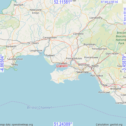
Llanelli GPS coordinates[2]
51° 40' 55.02" North, 4° 9' 42.876" West
| Map corner | latitude | longitude |
|---|---|---|
| Upper-left | 52.11581°, | -4.86504° |
| Center: | 51.68195°, | -4.16191° |
| Lower-right: | 51.24389°, | -3.45879° |
| Map W x H: | 96.9×96.9 km | = 60.2×60.2mi |
| max Lat: | 60.39635° ⇑71.6% North |
| Llanelli: | 51.68195° |
| min Lat: | ⇓28.4% South 34.60088° |
| min Long | Llanelli | max Long |
| -7.64133° | -4.16191° | 32.95536° |
| W 9.9%⇐ | ⇒90.1% E |
Elevation
Elevation of Llanelli is 13 m = 43 ft, and this is 59.9 m = 197 ft below average elevation for this country.
| Max E: |
515 m = 1690 ft | 88.2% |
| Avg. | 72.9 m = 239 ft | |
| Llanelli | 13 m = 43 ft | |
Min E: |
-30 m = -98 ft | 11.8% |
See also: Llanelli elevation on elevation.city.
Geographical zone
Llanelli is located in North temperate zone (between Tropic of Cancer and the Arctic Circle). Distance of this North polar circle is 1654.7 km =1028.2 mi to North.| Distance of | km | miles | from Llanelli |
|---|---|---|---|
| North Pole | 4260.6 | 2647.4 | to North |
| Arctic Circle | 1654.7 | 1028.2 | to North |
| Tropic Cancer | 3140.6 | 1951.5 | to South |
| Equator | 5746.5 | 3570.7 | to South |


Nearby cities:
15 places around Llanelli: (largest is in red/bold)
• Burry Port
5.9 km =3.7 mi,  272°
272°
• Carway
7.6 km =4.7 mi,  323°
323°
• Crofty
5.7 km =3.5 mi,  156°
156°
• Gorseinon
8.4 km =5.2 mi,  99°
99°
• Grovesend
8.5 km =5.3 mi,  87°
87°
• Llannon
8.7 km =5.4 mi,  20°
20°
• Llanrhidian
8.4 km =5.2 mi,  183°
183°
• Pen-clawdd
6.3 km =3.9 mi,  136°
136°
• Pont Henri
9.4 km =5.8 mi,  340°
340°
• Pontarddulais
9.2 km =5.7 mi,  67°
67°
• Pontlliw
10.5 km =6.5 mi,  84°
84°
• Pontyates
8.7 km =5.4 mi,  333°
333°
• Pontyberem
10.7 km =6.6 mi,  357°
357°
• Three Crosses
9.1 km =5.7 mi,  130°
130°
• Trimsaran
6.9 km =4.3 mi,  307°
307°
Sources, notices
• [Note1] Compared only with cities in United Kingdom existing in our database
• [Src1] Map data: © OpenStreetMap contributors (CC-BY-SA)
• [Src2] Other city data from geonames.org with taken over terms of usage.
• [Src3] Geographical zone / Annual Mean Temperature by Robert A. Rohde @ Wikipedia
