Llanrhidian geodata
Llanrhidian (Wales) is a populated place; located in United Kingdom in Europe/London (GMT+1) time zone. With population of 512 people, there are 4850 cities with bigger population in this country. Compared to other cities in United Kingdom, 74.2% of cities are located further ↑North; 90.2% of cities are located further →East and 53.7% of cities have higher elevation than Llanrhidian. Note1
Administrative division(s):
- Level 1: Wales
- Level 2: City and County of Swansea
- Level 3: Llanrhidian Lower


Llanrhidian GPS coordinates[2]
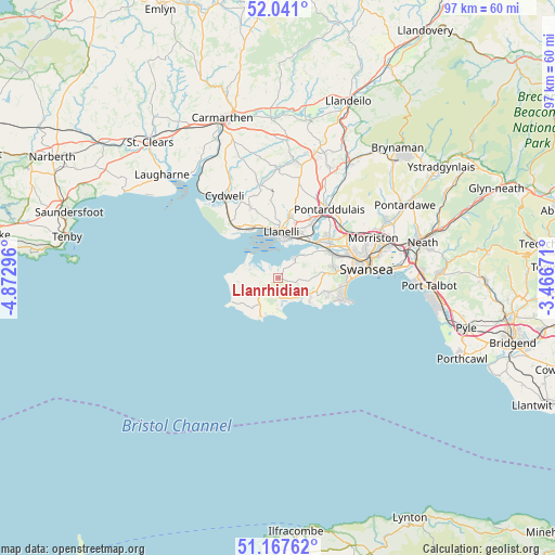
51° 36' 23.076" North, 4° 10' 11.424" West
| Map corner | latitude | longitude |
|---|---|---|
| Upper-left | 52.041°, | -4.87296° |
| Center: | 51.60641°, | -4.16984° |
| Lower-right: | 51.16762°, | -3.46671° |
| Map W x H: | 97.1×97.1 km | = 60.3×60.3mi |
| max Lat: | 60.39635° ⇑74.2% North |
| Llanrhidian: | 51.60641° |
| min Lat: | ⇓25.8% South 34.60088° |
| min Long | Llanrhidian | max Long |
| -7.64133° | -4.16984° | 32.95536° |
| W 9.8%⇐ | ⇒90.2% E |
Elevation
Elevation of Llanrhidian is 55 m = 180 ft, and this is 17.9 m = 59 ft below average elevation for this country.
| Max E: |
515 m = 1690 ft | 53.7% |
| Avg. | 72.9 m = 239 ft | |
| Llanrhidian | 55 m = 180 ft | |
Min E: |
-30 m = -98 ft | 46.3% |
See also: United Kingdom elevation on elevation.city.
Geographical zone
Llanrhidian is located in North temperate zone (between Tropic of Cancer and the Arctic Circle). Distance of this North polar circle is 1663.1 km =1033.4 mi to North.| Distance of | km | miles | from Llanrhidian |
|---|---|---|---|
| North Pole | 4269 | 2652.6 | to North |
| Arctic Circle | 1663.1 | 1033.4 | to North |
| Tropic Cancer | 3132.2 | 1946.3 | to South |
| Equator | 5738.1 | 3565.5 | to South |


Nearby cities:
15 places around Llanrhidian: (largest is in red/bold)
• Bishopston
9 km =5.6 mi,  110°
110°
• Burry Port
10.2 km =6.3 mi,  328°
328°
• Carway
15 km =9.3 mi,  344°
344°
• Crofty
4.2 km =2.6 mi,  41°
41°
• Gorseinon
11.3 km =7 mi,  51°
51°
• Grovesend
12.6 km =7.8 mi, 46°
• Llanelli
8.4 km =5.2 mi,  3°
3°
• Pen-clawdd
6.2 km =3.9 mi, 52°
• Pennard
6.6 km =4.1 mi,  120°
120°
• Pontarddulais
15 km =9.3 mi, 37°
• Pontlliw
14.5 km =9 mi, 49°
• Southgate
6.9 km =4.3 mi,  126°
126°
• Swansea
15.7 km =9.8 mi,  84°
84°
• Three Crosses
7.8 km =4.8 mi,  71°
71°
• Trimsaran
13.6 km =8.5 mi, 338°
Sources, notices
• [Note1] Compared only with cities in United Kingdom existing in our database
• [Src1] Map data: © OpenStreetMap contributors (CC-BY-SA)
• [Src2] Other city data from geonames.org with taken over terms of usage.
• [Src3] Geographical zone / Annual Mean Temperature by Robert A. Rohde @ Wikipedia
