Lindal in Furness geodata
Lindal in Furness (England) is a populated place; located in United Kingdom in Europe/London (GMT+1) time zone. With population of 755 people, there are 4135 cities with bigger population in this country. Compared to other cities in United Kingdom, 79.9% of cities are located further ↓South; 77.7% of cities are located further →East and 62.7% of cities have lower elevation than Lindal in Furness. Note1
Administrative division(s):
- Level 1: England
- Level 2: Cumbria
- Level 3: Barrow-in-Furness District
- Level 4: Lindal and Marton


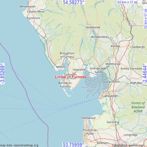
Lindal in Furness GPS coordinates[2]
54° 10' 23.556" North, 3° 8' 58.416" West
| Map corner | latitude | longitude |
|---|---|---|
| Upper-left | 54.58273°, | -3.85269° |
| Center: | 54.17321°, | -3.14956° |
| Lower-right: | 53.75959°, | -2.44644° |
| Map W x H: | 91.5×91.5 km | = 56.9×56.9mi |
| max Lat: | 60.39635° ⇑20.1% North |
| Lindal in Furness: | 54.17321° |
| min Lat: | ⇓79.9% South 34.60088° |
| min Long | Lindal in Furne | max Long |
| -7.64133° | -3.14956° | 32.95536° |
| W 22.3%⇐ | ⇒77.7% E |
Elevation
Elevation of Lindal in Furness is 81 m = 266 ft, and this is 8.1 m = 27 ft above average elevation for this country.
| Max E: |
515 m = 1690 ft | 37.3% |
| Lindal in Furness | 81 m 266 ft | |
| Avg. | 72.9 m = 239 ft | |
Min E: |
-30 m = -98 ft | 62.7% |
See also: United Kingdom elevation on elevation.city.
Geographical zone
Lindal in Furness is located in North temperate zone (between Tropic of Cancer and the Arctic Circle). Distance of this North polar circle is 1377.7 km =856.1 mi to North.| Distance of | km | miles | from Lindal in Furness |
|---|---|---|---|
| North Pole | 3983.6 | 2475.3 | to North |
| Arctic Circle | 1377.7 | 856.1 | to North |
| Tropic Cancer | 3417.6 | 2123.6 | to South |
| Equator | 6023.5 | 3742.8 | to South |


Nearby cities:
15 places around Lindal in Furness: (largest is in red/bold)
• Arnside
20.8 km =12.9 mi,  81°
81°
• Askam in Furness
3.9 km =2.4 mi,  293°
293°
• Backbarrow
13.9 km =8.6 mi,  48°
48°
• Barrow in Furness
8.6 km =5.3 mi,  216°
216°
• Broughton in Furness
12.2 km =7.6 mi,  340°
340°
• Dalton in Furness
2.6 km =1.6 mi,  229°
229°
• Flookburgh
11.5 km =7.1 mi,  89°
89°
• Grange-over-Sands
14.7 km =9.1 mi, 84°
• Haverigg
9.8 km =6.1 mi, 287°
• Kirkby-in-Furness
7 km =4.3 mi, 339°
• Lindale
17.2 km =10.7 mi,  73°
73°
• Millom
9 km =5.6 mi,  297°
297°
• Silverdale
21.7 km =13.5 mi, 91°
• Swarthmoor
2.5 km =1.6 mi,  58°
58°
• Ulverston
4.3 km =2.7 mi, 53°
Sources, notices
• [Note1] Compared only with cities in United Kingdom existing in our database
• [Src1] Map data: © OpenStreetMap contributors (CC-BY-SA)
• [Src2] Other city data from geonames.org with taken over terms of usage.
• [Src3] Geographical zone / Annual Mean Temperature by Robert A. Rohde @ Wikipedia
