Kirkby-in-Furness geodata
Kirkby-in-Furness (England) is a populated place; located in United Kingdom in Europe/London (GMT+0) time zone. With population of 554 people, there are 4721 cities with bigger population in this country. Compared to other cities in United Kingdom, 80.4% of cities are located further ↓South; 78.2% of cities are located further →East and 93.6% of cities have higher elevation than Kirkby-in-Furness. Note1
Administrative division(s):
- Level 1: England
- Level 2: Cumbria
- Level 3: South Lakeland District
- Level 4: Kirkby Ireleth


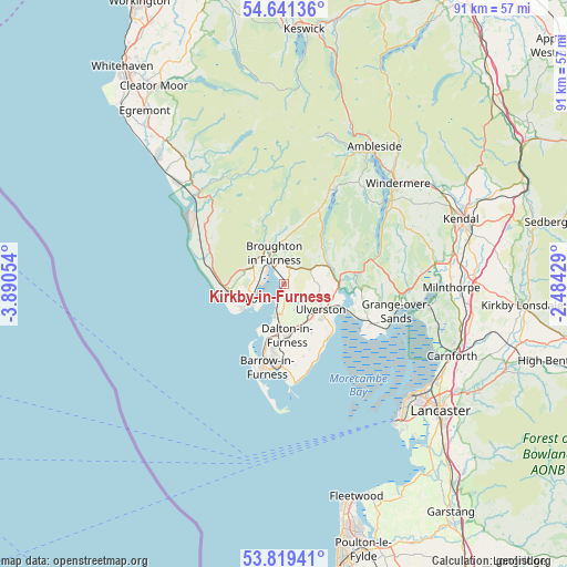
Kirkby-in-Furness GPS coordinates[2]
54° 13' 56.748" North, 3° 11' 14.676" West
| Map corner | latitude | longitude |
|---|---|---|
| Upper-left | 54.64136°, | -3.89054° |
| Center: | 54.23243°, | -3.18741° |
| Lower-right: | 53.81941°, | -2.48429° |
| Map W x H: | 91.4×91.4 km | = 56.8×56.8mi |
| max Lat: | 60.39635° ⇑19.6% North |
| Kirkby-in-Furness: | 54.23243° |
| min Lat: | ⇓80.4% South 34.60088° |
| min Long | Kirkby-in-Furne | max Long |
| -7.64133° | -3.18741° | 32.95536° |
| W 21.8%⇐ | ⇒78.2% E |
Elevation
Elevation of Kirkby-in-Furness is 9 m = 30 ft, and this is 63.9 m = 210 ft below average elevation for this country.
| Max E: |
515 m = 1690 ft | 93.6% |
| Avg. | 72.9 m = 239 ft | |
| Kirkby-in-Furness | 9 m = 30 ft | |
Min E: |
-30 m = -98 ft | 6.4% |
See also: United Kingdom elevation on elevation.city.
Geographical zone
Kirkby-in-Furness is located in North temperate zone (between Tropic of Cancer and the Arctic Circle). Distance of this North polar circle is 1371.1 km =852 mi to North.| Distance of | km | miles | from Kirkby-in-Furness |
|---|---|---|---|
| North Pole | 3977 | 2471.2 | to North |
| Arctic Circle | 1371.1 | 852 | to North |
| Tropic Cancer | 3424.2 | 2127.7 | to South |
| Equator | 6030.1 | 3746.9 | to South |


Nearby cities:
15 places around Kirkby-in-Furness: (largest is in red/bold)
• Arnside
23.2 km =14.4 mi,  98°
98°
• Askam in Furness
5.2 km =3.2 mi,  192°
192°
• Backbarrow
13.2 km =8.2 mi,  78°
78°
• Barrow in Furness
13.8 km =8.6 mi, 190°
• Broughton in Furness
5.2 km =3.2 mi,  342°
342°
• Coniston
16.8 km =10.4 mi,  25°
25°
• Dalton in Furness
8.3 km =5.2 mi,  176°
176°
• Flookburgh
15.4 km =9.6 mi,  114°
114°
• Grange-over-Sands
17.9 km =11.1 mi, 107°
• Haverigg
7.7 km =4.8 mi,  242°
242°
• Lindal in Furness
7 km =4.3 mi,  159°
159°
• Lindale
19 km =11.8 mi, 95°
• Millom
6 km =3.7 mi,  246°
246°
• Swarthmoor
7 km =4.3 mi,  139°
139°
• Ulverston
7.2 km =4.5 mi,  124°
124°
Sources, notices
• [Note1] Compared only with cities in United Kingdom existing in our database
• [Src1] Map data: © OpenStreetMap contributors (CC-BY-SA)
• [Src2] Other city data from geonames.org with taken over terms of usage.
• [Src3] Geographical zone / Annual Mean Temperature by Robert A. Rohde @ Wikipedia
