Larne geodata
Larne (Northern Ireland) is a seat of a second-order administrative division; located in United Kingdom in Europe/London (GMT+1) time zone. With population of 18,421 people, there are 646 cities with bigger population in this country. Compared to other cities in United Kingdom, 85.4% of cities are located further ↓South; 98% of cities are located further →East and 99% of cities have higher elevation than Larne. Note1


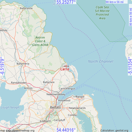
Larne GPS coordinates[2]
54° 51' 0" North, 5° 49' 0.012" West
| Map corner | latitude | longitude |
|---|---|---|
| Upper-left | 55.25277°, | -6.51979° |
| Center: | 54.85°, | -5.81667° |
| Lower-right: | 54.44316°, | -5.11354° |
| Map W x H: | 90×90 km | = 55.9×55.9mi |
| max Lat: | 60.39635° ⇑14.6% North |
| Larne: | 54.85° |
| min Lat: | ⇓85.4% South 34.60088° |
| min Long | Larne | max Long |
| -7.64133° | -5.81667° | 32.95536° |
| W 2%⇐ | ⇒98% E |
Elevation
Elevation of Larne is 4 m = 13 ft, and this is 68.9 m = 226 ft below average elevation for this country.
| Max E: |
515 m = 1690 ft | 99% |
| Avg. | 72.9 m = 239 ft | |
| Larne | 4 m = 13 ft | |
Min E: |
-30 m = -98 ft | 1% |
See also: United Kingdom elevation on elevation.city.
Geographical zone
Larne is located in North temperate zone (between Tropic of Cancer and the Arctic Circle). Distance of this North polar circle is 1302.4 km =809.3 mi to North.| Distance of | km | miles | from Larne |
|---|---|---|---|
| North Pole | 3908.3 | 2428.5 | to North |
| Arctic Circle | 1302.4 | 809.3 | to North |
| Tropic Cancer | 3492.8 | 2170.3 | to South |
| Equator | 6098.7 | 3789.6 | to South |


Nearby cities:
15 places around Larne: (largest is in red/bold)
• Ballyclare
16.1 km =10 mi,  226°
226°
• Bangor
23.8 km =14.8 mi,  156°
156°
• Broughshane
25.5 km =15.8 mi,  280°
280°
• Carnlough
19.3 km =12 mi,  324°
324°
• Carnmoney
20.4 km =12.7 mi,  204°
204°
• Carrickfergus
14.9 km =9.3 mi,  177°
177°
• Connor
25.2 km =15.7 mi,  257°
257°
• Doagh
20.4 km =12.7 mi,  236°
236°
• Glenariff
27.4 km =17 mi, 324°
• Greenisland
17 km =10.6 mi,  192°
192°
• Holywood
23.5 km =14.6 mi, 181°
• Jordanstown
19.3 km =12 mi, 196°
• Newtownabbey
22 km =13.7 mi, 195°
• Templepatrick
25.2 km =15.7 mi,  222°
222°
• Whitehead
12.7 km =7.9 mi,  147°
147°
Sources, notices
• [Note1] Compared only with cities in United Kingdom existing in our database
• [Src1] Map data: © OpenStreetMap contributors (CC-BY-SA)
• [Src2] Other city data from geonames.org with taken over terms of usage.
• [Src3] Geographical zone / Annual Mean Temperature by Robert A. Rohde @ Wikipedia
