Acton geodata
Acton (England) is a populated place; located in United Kingdom in Europe/London (GMT+0) time zone. With population of 53,689 people, there are 214 cities with bigger population in this country. Compared to other cities in United Kingdom, 77.4% of cities are located further ↑North; 81.6% of cities are located further ←West and 72.3% of cities have higher elevation than Acton. Note1


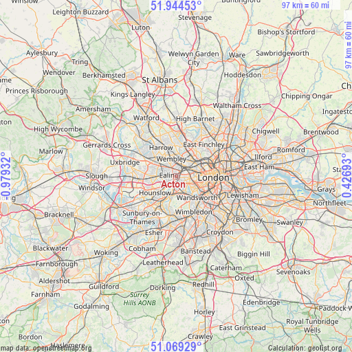
Acton GPS coordinates[2]
51° 30' 32.436" North, 0° 16' 34.32" West
| Map corner | latitude | longitude |
|---|---|---|
| Upper-left | 51.94453°, | -0.97932° |
| Center: | 51.50901°, | -0.2762° |
| Lower-right: | 51.06929°, | 0.42693° |
| Map W x H: | 97.3×97.3 km | = 60.5×60.5mi |
| max Lat: | 60.39635° ⇑77.4% North |
| Acton: | 51.50901° |
| min Lat: | ⇓22.6% South 34.60088° |
| min Long | Acton | max Long |
| -7.64133° | -0.2762° | 32.95536° |
| W 81.6%⇐ | ⇒18.4% E |
Elevation
Elevation of Acton is 30 m = 98 ft, and this is 42.9 m = 141 ft below average elevation for this country.
| Max E: |
515 m = 1690 ft | 72.3% |
| Avg. | 72.9 m = 239 ft | |
| Acton | 30 m = 98 ft | |
Min E: |
-30 m = -98 ft | 27.7% |
See also: Acton elevation on elevation.city.
Geographical zone
Acton is located in North temperate zone (between Tropic of Cancer and the Arctic Circle). Distance of this North polar circle is 1673.9 km =1040.1 mi to North.| Distance of | km | miles | from Acton |
|---|---|---|---|
| North Pole | 4279.8 | 2659.3 | to North |
| Arctic Circle | 1673.9 | 1040.1 | to North |
| Tropic Cancer | 3121.3 | 1939.5 | to South |
| Equator | 5727.3 | 3558.8 | to South |


Nearby cities:
15 places around Acton: (largest is in red/bold)
• Bayswater
6.4 km =4 mi,  87°
87°
• Brent
5.2 km =3.2 mi,  339°
339°
• Brentford
3.4 km =2.1 mi,  221°
221°
• Ealing
1.8 km =1.1 mi,  281°
281°
• Ealing Broadway
1.9 km =1.2 mi,  293°
293°
• Greenford
5.9 km =3.7 mi, 291°
• Hammersmith
3.7 km =2.3 mi,  117°
117°
• Hounslow
7.4 km =4.6 mi,  232°
232°
• Isleworth
5.9 km =3.7 mi, 230°
• Kensington
5.9 km =3.7 mi,  98°
98°
• Northolt
7.7 km =4.8 mi,  304°
304°
• Richmond
5.7 km =3.5 mi,  201°
201°
• Southall
6.6 km =4.1 mi,  269°
269°
• Wandsworth
7.4 km =4.6 mi,  140°
140°
• Wembley
5 km =3.1 mi, 343°
Sources, notices
• [Note1] Compared only with cities in United Kingdom existing in our database
• [Src1] Map data: © OpenStreetMap contributors (CC-BY-SA)
• [Src2] Other city data from geonames.org with taken over terms of usage.
• [Src3] Geographical zone / Annual Mean Temperature by Robert A. Rohde @ Wikipedia
