Horsham geodata
Horsham (England) is a populated place; located in United Kingdom in Europe/London (GMT+1) time zone. With population of 51,472 people, there are 226 cities with bigger population in this country. Compared to other cities in United Kingdom, 90% of cities are located further ↑North; 80.4% of cities are located further ←West and 55.9% of cities have higher elevation than Horsham. Note1


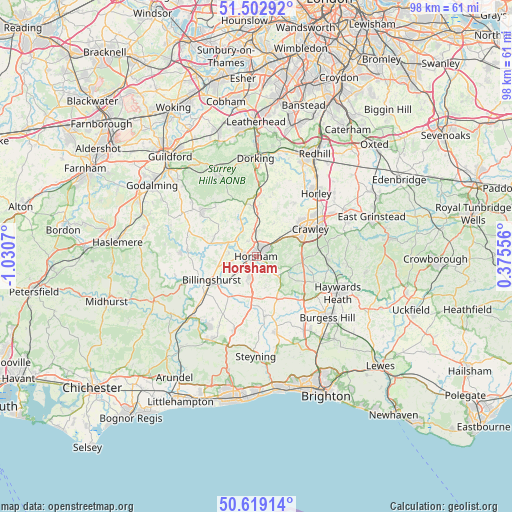
Horsham GPS coordinates[2]
51° 3' 47.304" North, 0° 19' 39.252" West
| Map corner | latitude | longitude |
|---|---|---|
| Upper-left | 51.50292°, | -1.0307° |
| Center: | 51.06314°, | -0.32757° |
| Lower-right: | 50.61914°, | 0.37556° |
| Map W x H: | 98.3×98.3 km | = 61.1×61.1mi |
| max Lat: | 60.39635° ⇑90% North |
| Horsham: | 51.06314° |
| min Lat: | ⇓10% South 34.60088° |
| min Long | Horsham | max Long |
| -7.64133° | -0.32757° | 32.95536° |
| W 80.4%⇐ | ⇒19.6% E |
Elevation
Elevation of Horsham is 52 m = 171 ft, and this is 20.9 m = 69 ft below average elevation for this country.
| Max E: |
515 m = 1690 ft | 55.9% |
| Avg. | 72.9 m = 239 ft | |
| Horsham | 52 m = 171 ft | |
Min E: |
-30 m = -98 ft | 44.1% |
See also: Horsham elevation on elevation.city.
Geographical zone
Horsham is located in North temperate zone (between Tropic of Cancer and the Arctic Circle). Distance of this North polar circle is 1723.5 km =1070.9 mi to North.| Distance of | km | miles | from Horsham |
|---|---|---|---|
| North Pole | 4329.4 | 2690.2 | to North |
| Arctic Circle | 1723.5 | 1070.9 | to North |
| Tropic Cancer | 3071.8 | 1908.7 | to South |
| Equator | 5677.7 | 3528 | to South |


Nearby cities:
15 places around Horsham: (largest is in red/bold)
• Barns Green
5.8 km =3.6 mi,  235°
235°
• Bewbush
8.6 km =5.3 mi,  58°
58°
• Billingshurst
9.9 km =6.2 mi, 243°
• Broadfield
9.3 km =5.8 mi,  65°
65°
• Capel
9.6 km =6 mi,  1°
1°
• Cowfold
9.1 km =5.7 mi,  154°
154°
• Crawley
11.5 km =7.1 mi, 61°
• Gossops Green
9.4 km =5.8 mi, 55°
• Handcross
8.9 km =5.5 mi,  96°
96°
• Ockley
9.6 km =6 mi,  344°
344°
• Rudgwick
9.1 km =5.7 mi,  287°
287°
• Rusper
7.3 km =4.5 mi,  27°
27°
• Slinfold
5.6 km =3.5 mi,  280°
280°
• Southwater
4.7 km =2.9 mi,  201°
201°
• Warnham
3.4 km =2.1 mi,  334°
334°
Sources, notices
• [Note1] Compared only with cities in United Kingdom existing in our database
• [Src1] Map data: © OpenStreetMap contributors (CC-BY-SA)
• [Src2] Other city data from geonames.org with taken over terms of usage.
• [Src3] Geographical zone / Annual Mean Temperature by Robert A. Rohde @ Wikipedia
