Belbroughton geodata
Belbroughton (England) is a populated place; located in United Kingdom in Europe/London (GMT+1) time zone. With population of 1,272 people, there are 3270 cities with bigger population in this country. Compared to other cities in United Kingdom, 51.9% of cities are located further ↑North; 57.2% of cities are located further →East and 79.3% of cities have lower elevation than Belbroughton. Note1
Administrative division(s):
- Level 1: England
- Level 2: Worcestershire
- Level 3: Bromsgrove District
- Level 4: Belbroughton


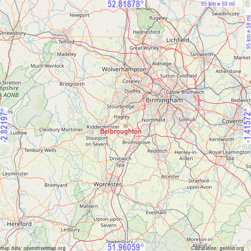
Belbroughton GPS coordinates[2]
52° 23' 30.372" North, 2° 7' 7.824" West
| Map corner | latitude | longitude |
|---|---|---|
| Upper-left | 52.81878°, | -2.82197° |
| Center: | 52.39177°, | -2.11884° |
| Lower-right: | 51.96059°, | -1.41572° |
| Map W x H: | 95.4×95.4 km | = 59.3×59.3mi |
| max Lat: | 60.39635° ⇑51.9% North |
| Belbroughton: | 52.39177° |
| min Lat: | ⇓48.1% South 34.60088° |
| min Long | Belbroughton | max Long |
| -7.64133° | -2.11884° | 32.95536° |
| W 42.8%⇐ | ⇒57.2% E |
Elevation
Elevation of Belbroughton is 116 m = 381 ft, and this is 43.1 m = 141 ft above average elevation for this country.
| Max E: |
515 m = 1690 ft | 20.7% |
| Belbroughton | 116 m 381 ft | |
| Avg. | 72.9 m = 239 ft | |
Min E: |
-30 m = -98 ft | 79.3% |
See also: United Kingdom elevation on elevation.city.
Geographical zone
Belbroughton is located in North temperate zone (between Tropic of Cancer and the Arctic Circle). Distance of this North polar circle is 1575.8 km =979.2 mi to North.| Distance of | km | miles | from Belbroughton |
|---|---|---|---|
| North Pole | 4181.6 | 2598.3 | to North |
| Arctic Circle | 1575.8 | 979.2 | to North |
| Tropic Cancer | 3219.5 | 2000.5 | to South |
| Equator | 5825.4 | 3619.7 | to South |


Nearby cities:
15 places around Belbroughton: (largest is in red/bold)
• Barnt Green
8.4 km =5.2 mi,  115°
115°
• Bartley Green
9.6 km =6 mi,  59°
59°
• Brierley Hill
10 km =6.2 mi,  359°
359°
• Bromsgrove
7.4 km =4.6 mi,  147°
147°
• Cradley Heath
9.3 km =5.8 mi,  15°
15°
• Hagley
3.9 km =2.4 mi,  350°
350°
• Halesowen
7.9 km =4.9 mi,  36°
36°
• Hartlebury
10.1 km =6.3 mi,  230°
230°
• Kidderminster
8.9 km =5.5 mi,  267°
267°
• Kinvere
10.1 km =6.3 mi,  309°
309°
• Netherton
10.5 km =6.5 mi,  13°
13°
• Romsley
5.2 km =3.2 mi,  53°
53°
• Stoke Prior
10.6 km =6.6 mi,  165°
165°
• Stone
6.2 km =3.9 mi,  243°
243°
• Stourbridge
7.3 km =4.5 mi, 347°
Sources, notices
• [Note1] Compared only with cities in United Kingdom existing in our database
• [Src1] Map data: © OpenStreetMap contributors (CC-BY-SA)
• [Src2] Other city data from geonames.org with taken over terms of usage.
• [Src3] Geographical zone / Annual Mean Temperature by Robert A. Rohde @ Wikipedia
