Goring-by-Sea geodata
Goring-by-Sea (England) is a populated place; located in United Kingdom in Europe/London (GMT+1) time zone. With population of 1,001 people, there are 3629 cities with bigger population in this country. Compared to other cities in United Kingdom, 95% of cities are located further ↑North; 78.4% of cities are located further ←West and 96.2% of cities have higher elevation than Goring-by-Sea. Note1


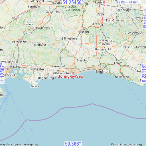
Goring-by-Sea GPS coordinates[2]
50° 48' 44.604" North, 0° 25' 18.984" West
| Map corner | latitude | longitude |
|---|---|---|
| Upper-left | 51.25456°, | -1.12507° |
| Center: | 50.81239°, | -0.42194° |
| Lower-right: | 50.366°, | 0.28118° |
| Map W x H: | 98.8×98.8 km | = 61.4×61.4mi |
| max Lat: | 60.39635° ⇑95% North |
| Goring-by-Sea: | 50.81239° |
| min Lat: | ⇓5% South 34.60088° |
| min Long | Goring-by-Sea | max Long |
| -7.64133° | -0.42194° | 32.95536° |
| W 78.4%⇐ | ⇒21.6% E |
Elevation
Elevation of Goring-by-Sea is 7 m = 23 ft, and this is 65.9 m = 216 ft below average elevation for this country.
| Max E: |
515 m = 1690 ft | 96.2% |
| Avg. | 72.9 m = 239 ft | |
| Goring-by-Sea | 7 m = 23 ft | |
Min E: |
-30 m = -98 ft | 3.8% |
See also: United Kingdom elevation on elevation.city.
Geographical zone
Goring-by-Sea is located in North temperate zone (between Tropic of Cancer and the Arctic Circle). Distance of this North polar circle is 1751.4 km =1088.3 mi to North.| Distance of | km | miles | from Goring-by-Sea |
|---|---|---|---|
| North Pole | 4357.3 | 2707.5 | to North |
| Arctic Circle | 1751.4 | 1088.3 | to North |
| Tropic Cancer | 3043.9 | 1891.4 | to South |
| Equator | 5649.8 | 3510.6 | to South |


Nearby cities:
15 places around Goring-by-Sea: (largest is in red/bold)
• Amberley
13.1 km =8.1 mi,  322°
322°
• Arundel
10.4 km =6.5 mi,  296°
296°
• Ashington
13.6 km =8.5 mi,  9°
9°
• Broadwater
3.7 km =2.3 mi,  60°
60°
• Findon
6.3 km =3.9 mi, 9°
• Lancing
7.2 km =4.5 mi,  75°
75°
• Littlehampton
8.4 km =5.2 mi,  269°
269°
• Rustington
6 km =3.7 mi, 267°
• Shoreham-by-Sea
10.6 km =6.6 mi, 76°
• Small Dole
14 km =8.7 mi,  46°
46°
• Steyning
10.6 km =6.6 mi,  38°
38°
• Storrington
11.9 km =7.4 mi,  348°
348°
• Washington
10.3 km =6.4 mi, 6°
• Worthing
3.3 km =2.1 mi, 79°
• Yapton
13.5 km =8.4 mi, 274°
Sources, notices
• [Note1] Compared only with cities in United Kingdom existing in our database
• [Src1] Map data: © OpenStreetMap contributors (CC-BY-SA)
• [Src2] Other city data from geonames.org with taken over terms of usage.
• [Src3] Geographical zone / Annual Mean Temperature by Robert A. Rohde @ Wikipedia
