Four Crosses geodata
Four Crosses (Wales) is a populated place; located in United Kingdom in Europe/London (GMT+1) time zone. With population of 1,438 people, there are 3103 cities with bigger population in this country. Compared to other cities in United Kingdom, 56.5% of cities are located further ↓South; 76.8% of cities are located further →East and 55.8% of cities have lower elevation than Four Crosses. Note1


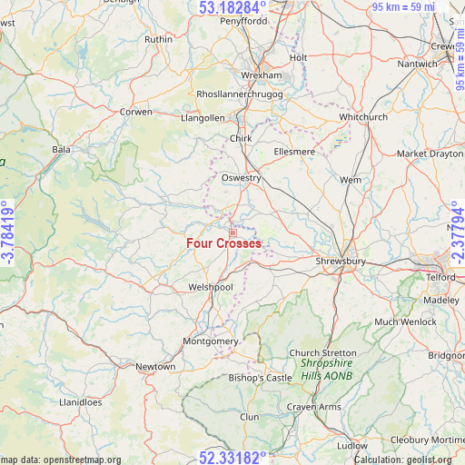
Four Crosses GPS coordinates[2]
52° 45' 33.876" North, 3° 4' 51.816" West
| Map corner | latitude | longitude |
|---|---|---|
| Upper-left | 53.18284°, | -3.78419° |
| Center: | 52.75941°, | -3.08106° |
| Lower-right: | 52.33182°, | -2.37794° |
| Map W x H: | 94.6×94.6 km | = 58.8×58.8mi |
| max Lat: | 60.39635° ⇑43.5% North |
| Four Crosses: | 52.75941° |
| min Lat: | ⇓56.5% South 34.60088° |
| min Long | Four Crosses | max Long |
| -7.64133° | -3.08106° | 32.95536° |
| W 23.2%⇐ | ⇒76.8% E |
Elevation
Elevation of Four Crosses is 70 m = 230 ft, and this is 2.9 m = 10 ft below average elevation for this country.
| Max E: |
515 m = 1690 ft | 44.2% |
| Avg. | 72.9 m = 239 ft | |
| Four Crosses | 70 m = 230 ft | |
Min E: |
-30 m = -98 ft | 55.8% |
See also: United Kingdom elevation on elevation.city.
Geographical zone
Four Crosses is located in North temperate zone (between Tropic of Cancer and the Arctic Circle). Distance of this North polar circle is 1534.9 km =953.7 mi to North.| Distance of | km | miles | from Four Crosses |
|---|---|---|---|
| North Pole | 4140.8 | 2573 | to North |
| Arctic Circle | 1534.9 | 953.7 | to North |
| Tropic Cancer | 3260.4 | 2025.9 | to South |
| Equator | 5866.3 | 3645.1 | to South |


Nearby cities:
15 places around Four Crosses: (largest is in red/bold)
• Ford
15 km =9.3 mi,  108°
108°
• Gobowen
15.5 km =9.6 mi,  11°
11°
• Great Ness
12.8 km =8 mi,  87°
87°
• Guilsfield
8.7 km =5.4 mi,  216°
216°
• Llanfechain
8.4 km =5.2 mi,  281°
281°
• Llanfyllin
12.9 km =8 mi,  273°
273°
• Llanymynech
2.4 km =1.5 mi,  347°
347°
• Oswestry
11.5 km =7.1 mi, 8°
• Pant
3.4 km =2.1 mi,  0°
0°
• Ruyton-XI-Towns
12.6 km =7.8 mi,  71°
71°
• Trefonen
8.3 km =5.2 mi, 351°
• Welshpool
11.9 km =7.4 mi,  201°
201°
• West Felton
10.3 km =6.4 mi,  44°
44°
• Westbury
12.4 km =7.7 mi,  136°
136°
• Whittington
13.7 km =8.5 mi,  22°
22°
Sources, notices
• [Note1] Compared only with cities in United Kingdom existing in our database
• [Src1] Map data: © OpenStreetMap contributors (CC-BY-SA)
• [Src2] Other city data from geonames.org with taken over terms of usage.
• [Src3] Geographical zone / Annual Mean Temperature by Robert A. Rohde @ Wikipedia
