Charlestown of Aberlour geodata
Charlestown of Aberlour (Scotland) is a populated place; located in United Kingdom in Europe/London (GMT+1) time zone. With population of 1,120 people, there are 3460 cities with bigger population in this country. Compared to other cities in United Kingdom, 98.4% of cities are located further ↓South; 78.6% of cities are located further →East and 67.6% of cities have lower elevation than Charlestown of Aberlour. Note1
Current local time in Charlestown of Aberlour:
07:52 AM, FridayDifference from your time zone: hours


Charlestown of Aberlour GPS coordinates[2]
57° 28' 14.736" North, 3° 13' 30.324" West
| Map corner | latitude | longitude |
|---|---|---|
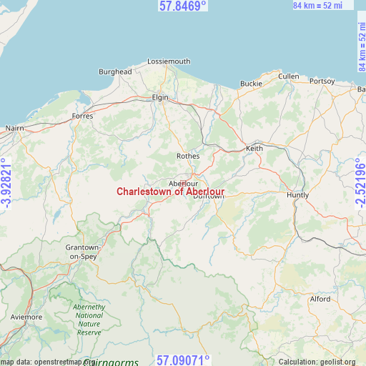
| Upper-left | 57.8469°, | -3.92821° |
| Center: | 57.47076°, | -3.22509° |
| Lower-right: | 57.09071°, | -2.52196° |
| Map W x H: | 84.1×84.1 km | = 52.3×52.3mi |
| max Lat: | 60.39635° ⇑1.6% North |
| Charlestown of Aberlour: | 57.47076° |
| min Lat: | ⇓98.4% South 34.60088° |
| min Long | Charlestown of | max Long |
| -7.64133° | -3.22509° | 32.95536° |
| W 21.4%⇐ | ⇒78.6% E |
Elevation
Elevation of Charlestown of Aberlour is 91 m = 299 ft, and this is 18.1 m = 59 ft above average elevation for this country.
| Max E: |
515 m = 1690 ft | 32.4% |
| Charlestown of Aberlour | 91 m 299 ft | |
| Avg. | 72.9 m = 239 ft | |
Min E: |
-30 m = -98 ft | 67.6% |
See also: United Kingdom elevation on elevation.city.
Geographical zone
Charlestown of Aberlour is located in North temperate zone (between Tropic of Cancer and the Arctic Circle). Distance of this North polar circle is 1011 km =628.2 mi to North.| Distance of | km | miles | from Charlestown of Aberlour |
|---|---|---|---|
| North Pole | 3616.9 | 2247.4 | to North |
| Arctic Circle | 1011 | 628.2 | to North |
| Tropic Cancer | 3784.2 | 2351.4 | to South |
| Equator | 6390.1 | 3970.6 | to South |


Nearby cities:
15 places around Charlestown of Aberlour: (largest is in red/bold)
• Bridgend
25.7 km =16 mi,  107°
107°
• Buckie
27.7 km =17.2 mi,  34°
34°
• Dufftown
6.5 km =4 mi,  115°
115°
• Elgin
20.6 km =12.8 mi,  344°
344°
• Fochabers
17.6 km =10.9 mi, 25°
• Garmouth
22.6 km =14 mi,  17°
17°
• Grantown on Spey
27.8 km =17.3 mi,  235°
235°
• Huntly
26.4 km =16.4 mi,  95°
95°
• Keith
18.1 km =11.2 mi,  66°
66°
• Kinloss
27.5 km =17.1 mi,  311°
311°
• Lhanbryde
18.3 km =11.4 mi,  1°
1°
• Lossiemouth
28.1 km =17.5 mi,  352°
352°
• Mosstodloch
18.3 km =11.4 mi, 19°
• Portgordon
24.9 km =15.5 mi, 30°
• Rothes
6.3 km =3.9 mi,  10°
10°
Sources, notices
• [Note1] Compared only with cities in United Kingdom existing in our database
• [Src1] Map data: © OpenStreetMap contributors (CC-BY-SA)
• [Src2] Other city data from geonames.org with taken over terms of usage.
• [Src3] Geographical zone / Annual Mean Temperature by Robert A. Rohde @ Wikipedia
