Crieff geodata
Crieff (Scotland) is a populated place; located in United Kingdom in Europe/London (GMT+0) time zone. With population of 7,430 people, there are 1291 cities with bigger population in this country. Compared to other cities in United Kingdom, 96.3% of cities are located further ↓South; 86.3% of cities are located further →East and 64% of cities have lower elevation than Crieff. Note1


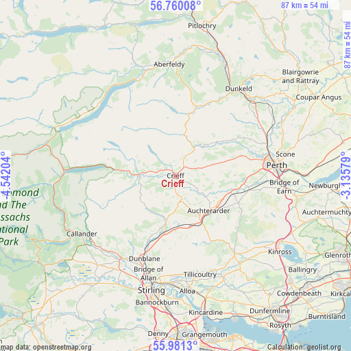
Crieff GPS coordinates[2]
56° 22' 21.648" North, 3° 50' 20.076" West
| Map corner | latitude | longitude |
|---|---|---|
| Upper-left | 56.76008°, | -4.54204° |
| Center: | 56.37268°, | -3.83891° |
| Lower-right: | 55.9813°, | -3.13579° |
| Map W x H: | 86.6×86.6 km | = 53.8×53.8mi |
| max Lat: | 60.39635° ⇑3.7% North |
| Crieff: | 56.37268° |
| min Lat: | ⇓96.3% South 34.60088° |
| min Long | Crieff | max Long |
| -7.64133° | -3.83891° | 32.95536° |
| W 13.7%⇐ | ⇒86.3% E |
Elevation
Elevation of Crieff is 84 m = 276 ft, and this is 11.1 m = 36 ft above average elevation for this country.
| Max E: |
515 m = 1690 ft | 36% |
| Crieff | 84 m 276 ft | |
| Avg. | 72.9 m = 239 ft | |
Min E: |
-30 m = -98 ft | 64% |
See also: United Kingdom elevation on elevation.city.
Geographical zone
Crieff is located in North temperate zone (between Tropic of Cancer and the Arctic Circle). Distance of this North polar circle is 1133.1 km =704.1 mi to North.| Distance of | km | miles | from Crieff |
|---|---|---|---|
| North Pole | 3739 | 2323.3 | to North |
| Arctic Circle | 1133.1 | 704.1 | to North |
| Tropic Cancer | 3662.1 | 2275.5 | to South |
| Equator | 6268.1 | 3894.8 | to South |


Nearby cities:
15 places around Crieff: (largest is in red/bold)
• Almondbank
20.4 km =12.7 mi,  75°
75°
• Alva
24.5 km =15.2 mi,  175°
175°
• Auchterarder
11.8 km =7.3 mi,  136°
136°
• Bankfoot
24.4 km =15.2 mi,  54°
54°
• Blackford
13 km =8.1 mi,  164°
164°
• Braco
12.3 km =7.6 mi,  191°
191°
• Comrie
8.6 km =5.3 mi,  267°
267°
• Doune
24.2 km =15 mi,  213°
213°
• Dunblane
21.9 km =13.6 mi,  200°
200°
• Dunning
17 km =10.6 mi,  113°
113°
• Forgandenny
22.4 km =13.9 mi,  97°
97°
• Luncarty
24.4 km =15.2 mi,  68°
68°
• Menstrie
24.6 km =15.3 mi, 182°
• Methven
16.8 km =10.4 mi, 72°
• Muthill
4.5 km =2.8 mi, 175°
Sources, notices
• [Note1] Compared only with cities in United Kingdom existing in our database
• [Src1] Map data: © OpenStreetMap contributors (CC-BY-SA)
• [Src2] Other city data from geonames.org with taken over terms of usage.
• [Src3] Geographical zone / Annual Mean Temperature by Robert A. Rohde @ Wikipedia
