Corse geodata
Corse (England) is a populated place; located in United Kingdom in Europe/London (GMT+1) time zone. With population of 1,178 people, there are 3387 cities with bigger population in this country. Compared to other cities in United Kingdom, 63.2% of cities are located further ↑North; 61.4% of cities are located further →East and 74.7% of cities have higher elevation than Corse. Note1
Administrative division(s):
- Level 1: England
- Level 2: Gloucestershire
- Level 3: Forest of Dean District
- Level 4: Corse


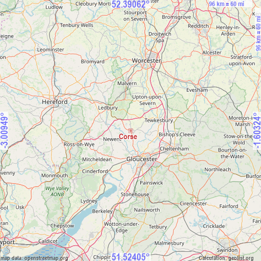
Corse GPS coordinates[2]
51° 57' 33.948" North, 2° 18' 22.896" West
| Map corner | latitude | longitude |
|---|---|---|
| Upper-left | 52.39062°, | -3.00949° |
| Center: | 51.95943°, | -2.30636° |
| Lower-right: | 51.52405°, | -1.60324° |
| Map W x H: | 96.4×96.4 km | = 59.9×59.9mi |
| max Lat: | 60.39635° ⇑63.2% North |
| Corse: | 51.95943° |
| min Lat: | ⇓36.8% South 34.60088° |
| min Long | Corse | max Long |
| -7.64133° | -2.30636° | 32.95536° |
| W 38.6%⇐ | ⇒61.4% E |
Elevation
Elevation of Corse is 27 m = 89 ft, and this is 45.9 m = 151 ft below average elevation for this country.
| Max E: |
515 m = 1690 ft | 74.7% |
| Avg. | 72.9 m = 239 ft | |
| Corse | 27 m = 89 ft | |
Min E: |
-30 m = -98 ft | 25.3% |
See also: United Kingdom elevation on elevation.city.
Geographical zone
Corse is located in North temperate zone (between Tropic of Cancer and the Arctic Circle). Distance of this North polar circle is 1623.8 km =1009 mi to North.| Distance of | km | miles | from Corse |
|---|---|---|---|
| North Pole | 4229.7 | 2628.2 | to North |
| Arctic Circle | 1623.8 | 1009 | to North |
| Tropic Cancer | 3171.4 | 1970.6 | to South |
| Equator | 5777.3 | 3589.8 | to South |


Nearby cities:
15 places around Corse: (largest is in red/bold)
• Apperley
7.2 km =4.5 mi,  95°
95°
• Ashleworth
4 km =2.5 mi,  147°
147°
• Barnwood
12.8 km =8 mi, 145°
• Donnington
8.8 km =5.5 mi,  300°
300°
• Dymock
9.4 km =5.8 mi,  283°
283°
• Gloucester
11.3 km =7 mi,  157°
157°
• Hartpury
4 km =2.5 mi,  166°
166°
• Huntley
11.7 km =7.3 mi,  213°
213°
• Ledbury
11.9 km =7.4 mi,  316°
316°
• Newent
7.5 km =4.7 mi,  247°
247°
• Tewkesbury
10.7 km =6.6 mi,  69°
69°
• Twigworth
8.7 km =5.4 mi,  138°
138°
• Uckington
13 km =8.1 mi,  108°
108°
• Upton upon Severn
13 km =8.1 mi,  27°
27°
• Welland
10.9 km =6.8 mi,  2°
2°
Sources, notices
• [Note1] Compared only with cities in United Kingdom existing in our database
• [Src1] Map data: © OpenStreetMap contributors (CC-BY-SA)
• [Src2] Other city data from geonames.org with taken over terms of usage.
• [Src3] Geographical zone / Annual Mean Temperature by Robert A. Rohde @ Wikipedia
