Gloucester geodata
Gloucester (England) is a seat of a second-order administrative division; located in United Kingdom in Europe/London (GMT+1) time zone. With population of 150,053 people, there are 59 cities with bigger population in this country. Compared to other cities in United Kingdom, 66.1% of cities are located further ↑North; 60.2% of cities are located further →East and 77.1% of cities have higher elevation than Gloucester. Note1


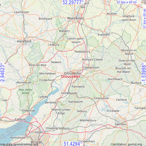
Gloucester GPS coordinates[2]
51° 51' 56.448" North, 2° 14' 35.16" West
| Map corner | latitude | longitude |
|---|---|---|
| Upper-left | 52.29777°, | -2.94623° |
| Center: | 51.86568°, | -2.2431° |
| Lower-right: | 51.4294°, | -1.53998° |
| Map W x H: | 96.6×96.6 km | = 60×60mi |
| max Lat: | 60.39635° ⇑66.1% North |
| Gloucester: | 51.86568° |
| min Lat: | ⇓33.9% South 34.60088° |
| min Long | Gloucester | max Long |
| -7.64133° | -2.2431° | 32.95536° |
| W 39.8%⇐ | ⇒60.2% E |
Elevation
Elevation of Gloucester is 24 m = 79 ft, and this is 48.9 m = 160 ft below average elevation for this country.
| Max E: |
515 m = 1690 ft | 77.1% |
| Avg. | 72.9 m = 239 ft | |
| Gloucester | 24 m = 79 ft | |
Min E: |
-30 m = -98 ft | 22.9% |
See also: Gloucester elevation on elevation.city.
Geographical zone
Gloucester is located in North temperate zone (between Tropic of Cancer and the Arctic Circle). Distance of this North polar circle is 1634.3 km =1015.5 mi to North.| Distance of | km | miles | from Gloucester |
|---|---|---|---|
| North Pole | 4240.1 | 2634.7 | to North |
| Arctic Circle | 1634.3 | 1015.5 | to North |
| Tropic Cancer | 3161 | 1964.2 | to South |
| Equator | 5766.9 | 3583.4 | to South |


Nearby cities:
15 places around Gloucester: (largest is in red/bold)
• Apperley
10.1 km =6.3 mi,  16°
16°
• Ashleworth
7.4 km =4.6 mi,  342°
342°
• Barnwood
2.9 km =1.8 mi,  93°
93°
• Cheltenham
11.8 km =7.3 mi,  71°
71°
• Churchdown
5.1 km =3.2 mi,  75°
75°
• Corse
11.3 km =7 mi, 337°
• Hartpury
7.4 km =4.6 mi,  332°
332°
• Huntley
10.9 km =6.8 mi,  273°
273°
• Painswick
9.5 km =5.9 mi,  159°
159°
• Shurdington
8.4 km =5.2 mi, 92°
• Stonehouse
13.2 km =8.2 mi,  192°
192°
• Stroud
13.2 km =8.2 mi,  167°
167°
• Swindon
11.8 km =7.3 mi,  57°
57°
• Twigworth
4.1 km =2.5 mi, 19°
• Uckington
10.3 km =6.4 mi,  51°
51°
Sources, notices
• [Note1] Compared only with cities in United Kingdom existing in our database
• [Src1] Map data: © OpenStreetMap contributors (CC-BY-SA)
• [Src2] Other city data from geonames.org with taken over terms of usage.
• [Src3] Geographical zone / Annual Mean Temperature by Robert A. Rohde @ Wikipedia
