Twigworth geodata
Twigworth (England) is a populated place; located in United Kingdom in Europe/London (GMT+1) time zone. With population of 728 people, there are 4198 cities with bigger population in this country. Compared to other cities in United Kingdom, 64.9% of cities are located further ↑North; 59.7% of cities are located further →East and 88.2% of cities have higher elevation than Twigworth. Note1
Administrative division(s):
- Level 1: England
- Level 2: Gloucestershire
- Level 3: Tewkesbury District
- Level 4: Twigworth


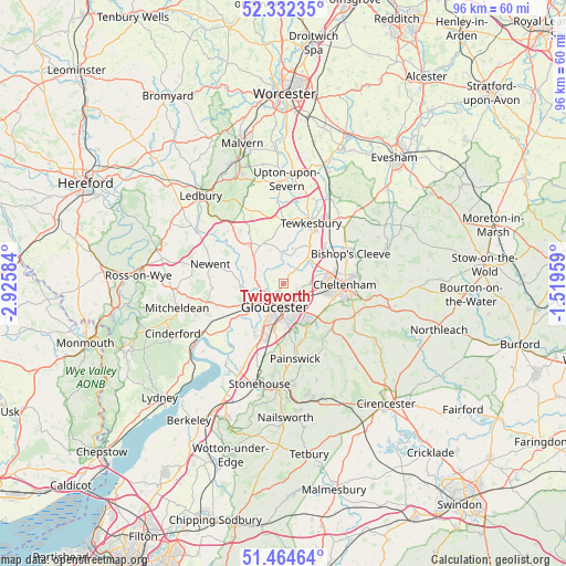
Twigworth GPS coordinates[2]
51° 54' 2.124" North, 2° 13' 21.756" West
| Map corner | latitude | longitude |
|---|---|---|
| Upper-left | 52.33235°, | -2.92584° |
| Center: | 51.90059°, | -2.22271° |
| Lower-right: | 51.46464°, | -1.51959° |
| Map W x H: | 96.5×96.5 km | = 60×60mi |
| max Lat: | 60.39635° ⇑64.9% North |
| Twigworth: | 51.90059° |
| min Lat: | ⇓35.1% South 34.60088° |
| min Long | Twigworth | max Long |
| -7.64133° | -2.22271° | 32.95536° |
| W 40.3%⇐ | ⇒59.7% E |
Elevation
Elevation of Twigworth is 13 m = 43 ft, and this is 59.9 m = 197 ft below average elevation for this country.
| Max E: |
515 m = 1690 ft | 88.2% |
| Avg. | 72.9 m = 239 ft | |
| Twigworth | 13 m = 43 ft | |
Min E: |
-30 m = -98 ft | 11.8% |
See also: United Kingdom elevation on elevation.city.
Geographical zone
Twigworth is located in North temperate zone (between Tropic of Cancer and the Arctic Circle). Distance of this North polar circle is 1630.4 km =1013.1 mi to North.| Distance of | km | miles | from Twigworth |
|---|---|---|---|
| North Pole | 4236.3 | 2632.3 | to North |
| Arctic Circle | 1630.4 | 1013.1 | to North |
| Tropic Cancer | 3164.9 | 1966.6 | to South |
| Equator | 5770.8 | 3585.8 | to South |


Nearby cities:
15 places around Twigworth: (largest is in red/bold)
• Apperley
6 km =3.7 mi,  13°
13°
• Ashleworth
4.8 km =3 mi,  311°
311°
• Barnwood
4.3 km =2.7 mi,  159°
159°
• Bishops Cleeve
12.1 km =7.5 mi,  64°
64°
• Charlton Kings
12.5 km =7.8 mi,  98°
98°
• Cheltenham
9.8 km =6.1 mi,  90°
90°
• Churchdown
4.4 km =2.7 mi,  125°
125°
• Corse
8.7 km =5.4 mi,  318°
318°
• Gloucester
4.1 km =2.5 mi,  199°
199°
• Hartpury
5.5 km =3.4 mi,  298°
298°
• Huntley
12.7 km =7.9 mi,  255°
255°
• Shurdington
8.2 km =5.1 mi,  121°
121°
• Swindon
8.9 km =5.5 mi,  73°
73°
• Tewkesbury
11.1 km =6.9 mi,  22°
22°
• Uckington
7.1 km =4.4 mi, 69°
Sources, notices
• [Note1] Compared only with cities in United Kingdom existing in our database
• [Src1] Map data: © OpenStreetMap contributors (CC-BY-SA)
• [Src2] Other city data from geonames.org with taken over terms of usage.
• [Src3] Geographical zone / Annual Mean Temperature by Robert A. Rohde @ Wikipedia
