Rossendale geodata
Rossendale (England) is a populated locality; located in United Kingdom in Europe/London (GMT+1) time zone. With population of 67,400 people, there are 156 cities with bigger population in this country. Compared to other cities in United Kingdom, 73.4% of cities are located further ↓South; 60.7% of cities are located further →East and 99.9% of cities have lower elevation than Rossendale. Note1


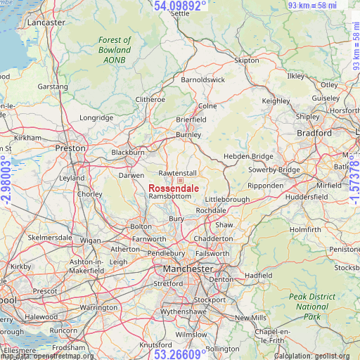
Rossendale GPS coordinates[2]
53° 41' 4.416" North, 2° 16' 36.84" West
| Map corner | latitude | longitude |
|---|---|---|
| Upper-left | 54.09892°, | -2.98003° |
| Center: | 53.68456°, | -2.2769° |
| Lower-right: | 53.26609°, | -1.57378° |
| Map W x H: | 92.6×92.6 km | = 57.5×57.5mi |
| max Lat: | 60.39635° ⇑26.6% North |
| Rossendale: | 53.68456° |
| min Lat: | ⇓73.4% South 34.60088° |
| min Long | Rossendale | max Long |
| -7.64133° | -2.2769° | 32.95536° |
| W 39.3%⇐ | ⇒60.7% E |
Elevation
Elevation of Rossendale is 380 m = 1247 ft, and this is 307.1 m = 1008 ft above average elevation for this country.
| Max E: |
515 m = 1690 ft | 0.099999999999994% |
| Rossendale | 380 m 1247 ft | |
| Avg. | 72.9 m = 239 ft | |
Min E: |
-30 m = -98 ft | 99.9% |
See also: Rossendale elevation on elevation.city.
Geographical zone
Rossendale is located in North temperate zone (between Tropic of Cancer and the Arctic Circle). Distance of this North polar circle is 1432 km =889.8 mi to North.| Distance of | km | miles | from Rossendale |
|---|---|---|---|
| North Pole | 4037.9 | 2509 | to North |
| Arctic Circle | 1432 | 889.8 | to North |
| Tropic Cancer | 3363.2 | 2089.8 | to South |
| Equator | 5969.2 | 3709.1 | to South |


Nearby cities:
15 places around Rossendale: (largest is in red/bold)
• Accrington
9.4 km =5.8 mi,  325°
325°
• Bacup
5.4 km =3.4 mi,  67°
67°
• Bury
9.5 km =5.9 mi,  189°
189°
• Church
10.6 km =6.6 mi,  314°
314°
• Cornholme
10.5 km =6.5 mi,  59°
59°
• Edenfield
2.7 km =1.7 mi,  222°
222°
• Edgworth
8.8 km =5.5 mi,  241°
241°
• Hameldon Hill
8 km =5 mi,  352°
352°
• Haslingden
3.7 km =2.3 mi,  303°
303°
• Ramsbottom
4.9 km =3 mi,  212°
212°
• Rawtenstall
1.9 km =1.2 mi,  344°
344°
• Rochdale
10.9 km =6.8 mi,  132°
132°
• Tottington
9 km =5.6 mi, 207°
• Wardle
10.2 km =6.3 mi,  112°
112°
• Whitworth
7.3 km =4.5 mi,  115°
115°
Sources, notices
• [Note1] Compared only with cities in United Kingdom existing in our database
• [Src1] Map data: © OpenStreetMap contributors (CC-BY-SA)
• [Src2] Other city data from geonames.org with taken over terms of usage.
• [Src3] Geographical zone / Annual Mean Temperature by Robert A. Rohde @ Wikipedia
