Collingbourne Kingston geodata
Collingbourne Kingston (England) is a seat of a third-order administrative division; located in United Kingdom in Europe/London (GMT+1) time zone. With population of 511 people, there are 4854 cities with bigger population in this country. Compared to other cities in United Kingdom, 84.3% of cities are located further ↑North; 51.7% of cities are located further ←West and 88.3% of cities have lower elevation than Collingbourne Kingston. Note1
Current local time in Collingbourne Kingston:
11:20 AM, TuesdayDifference from your time zone: hours


Collingbourne Kingston GPS coordinates[2]
51° 18' 3.78" North, 1° 39' 31.536" West
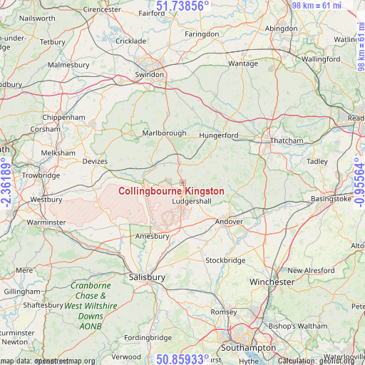
| Map corner | latitude | longitude |
|---|---|---|
| Upper-left | 51.73856°, | -2.36189° |
| Center: | 51.30105°, | -1.65876° |
| Lower-right: | 50.85933°, | -0.95564° |
| Map W x H: | 97.8×97.8 km | = 60.8×60.8mi |
| max Lat: | 60.39635° ⇑84.3% North |
| Collingbourne Kingston: | 51.30105° |
| min Lat: | ⇓15.7% South 34.60088° |
| min Long | Collingbourne K | max Long |
| -7.64133° | -1.65876° | 32.95536° |
| W 51.7%⇐ | ⇒48.3% E |
Elevation
Elevation of Collingbourne Kingston is 144 m = 472 ft, and this is 71.1 m = 233 ft above average elevation for this country.
| Max E: |
515 m = 1690 ft | 11.7% |
| Collingbourne Kingston | 144 m 472 ft | |
| Avg. | 72.9 m = 239 ft | |
Min E: |
-30 m = -98 ft | 88.3% |
See also: United Kingdom elevation on elevation.city.
Geographical zone
Collingbourne Kingston is located in North temperate zone (between Tropic of Cancer and the Arctic Circle). Distance of this North polar circle is 1697 km =1054.5 mi to North.| Distance of | km | miles | from Collingbourne Kingston |
|---|---|---|---|
| North Pole | 4302.9 | 2673.7 | to North |
| Arctic Circle | 1697 | 1054.5 | to North |
| Tropic Cancer | 3098.2 | 1925.1 | to South |
| Equator | 5704.1 | 3544.4 | to South |


Nearby cities:
15 places around Collingbourne Kingston: (largest is in red/bold)
• Appleshaw
9.6 km =6 mi,  137°
137°
• Burbage
5.7 km =3.5 mi,  351°
351°
• Collingbourne Ducis
1.8 km =1.1 mi,  166°
166°
• Great Bedwyn
9.6 km =6 mi,  24°
24°
• Huish
12.1 km =7.5 mi,  309°
309°
• Ludgershall
5.7 km =3.5 mi,  153°
153°
• Milston
13 km =8.1 mi,  216°
216°
• Netheravon
11.7 km =7.3 mi,  231°
231°
• Pewsey
8.5 km =5.3 mi,  299°
299°
• Rushall
11.2 km =7 mi,  259°
259°
• Shalbourne
10.2 km =6.3 mi,  47°
47°
• Tidworth
7.7 km =4.8 mi,  182°
182°
• Vernham Dean
10.2 km =6.3 mi,  86°
86°
• Weyhill
11.8 km =7.3 mi, 140°
• Woodborough
13.2 km =8.2 mi,  288°
288°
Sources, notices
• [Note1] Compared only with cities in United Kingdom existing in our database
• [Src1] Map data: © OpenStreetMap contributors (CC-BY-SA)
• [Src2] Other city data from geonames.org with taken over terms of usage.
• [Src3] Geographical zone / Annual Mean Temperature by Robert A. Rohde @ Wikipedia
