Vernham Dean geodata
Vernham Dean (England) is a populated place; located in United Kingdom in Europe/London (GMT+1) time zone. With population of 552 people, there are 4729 cities with bigger population in this country. Compared to other cities in United Kingdom, 84% of cities are located further ↑North; 55.2% of cities are located further ←West and 84.5% of cities have lower elevation than Vernham Dean. Note1
Administrative division(s):
- Level 1: England
- Level 2: Hampshire
- Level 3: Test Valley District
- Level 4: Vernhams Dean


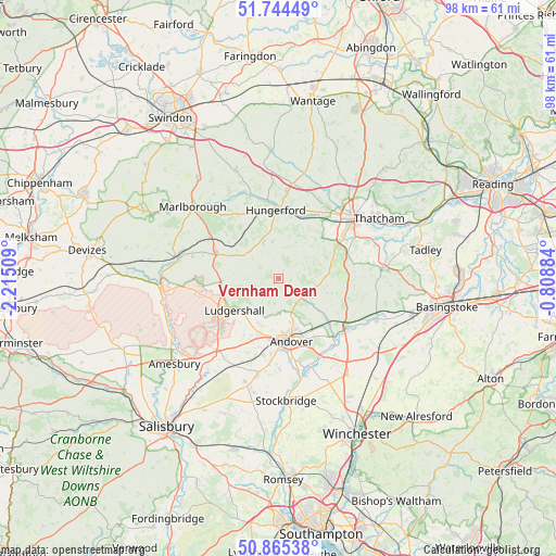
Vernham Dean GPS coordinates[2]
51° 18' 25.344" North, 1° 30' 43.092" West
| Map corner | latitude | longitude |
|---|---|---|
| Upper-left | 51.74449°, | -2.21509° |
| Center: | 51.30704°, | -1.51197° |
| Lower-right: | 50.86538°, | -0.80884° |
| Map W x H: | 97.7×97.7 km | = 60.7×60.7mi |
| max Lat: | 60.39635° ⇑84% North |
| Vernham Dean: | 51.30704° |
| min Lat: | ⇓16% South 34.60088° |
| min Long | Vernham Dean | max Long |
| -7.64133° | -1.51197° | 32.95536° |
| W 55.2%⇐ | ⇒44.8% E |
Elevation
Elevation of Vernham Dean is 131 m = 430 ft, and this is 58.1 m = 191 ft above average elevation for this country.
| Max E: |
515 m = 1690 ft | 15.5% |
| Vernham Dean | 131 m 430 ft | |
| Avg. | 72.9 m = 239 ft | |
Min E: |
-30 m = -98 ft | 84.5% |
See also: United Kingdom elevation on elevation.city.
Geographical zone
Vernham Dean is located in North temperate zone (between Tropic of Cancer and the Arctic Circle). Distance of this North polar circle is 1696.4 km =1054.1 mi to North.| Distance of | km | miles | from Vernham Dean |
|---|---|---|---|
| North Pole | 4302.3 | 2673.3 | to North |
| Arctic Circle | 1696.4 | 1054.1 | to North |
| Tropic Cancer | 3098.9 | 1925.6 | to South |
| Equator | 5704.8 | 3544.8 | to South |


Nearby cities:
15 places around Vernham Dean: (largest is in red/bold)
• Andover
10.7 km =6.6 mi,  173°
173°
• Appleshaw
8.6 km =5.3 mi,  205°
205°
• Burbage
12.1 km =7.5 mi,  294°
294°
• Collingbourne Ducis
10.1 km =6.3 mi,  256°
256°
• Collingbourne Kingston
10.2 km =6.3 mi,  266°
266°
• Great Bedwyn
10.2 km =6.3 mi,  322°
322°
• Highclere
10.1 km =6.3 mi,  69°
69°
• Hungerford
12 km =7.5 mi,  358°
358°
• Hurstbourne Tarrant
5.3 km =3.3 mi,  129°
129°
• Kintbury
11.2 km =7 mi,  23°
23°
• Ludgershall
9.6 km =6 mi,  233°
233°
• Monxton
12.5 km =7.8 mi,  193°
193°
• Shalbourne
6.8 km =4.2 mi,  336°
336°
• St Mary Bourne
9.6 km =6 mi, 127°
• Weyhill
10.1 km =6.3 mi,  195°
195°
Sources, notices
• [Note1] Compared only with cities in United Kingdom existing in our database
• [Src1] Map data: © OpenStreetMap contributors (CC-BY-SA)
• [Src2] Other city data from geonames.org with taken over terms of usage.
• [Src3] Geographical zone / Annual Mean Temperature by Robert A. Rohde @ Wikipedia
