Coity geodata
Coity (Wales) is a populated place; located in United Kingdom in Europe/London (GMT+0) time zone. With population of 41,352 people, there are 290 cities with bigger population in this country. Compared to other cities in United Kingdom, 77% of cities are located further ↑North; 83.1% of cities are located further →East and 52.4% of cities have lower elevation than Coity. Note1


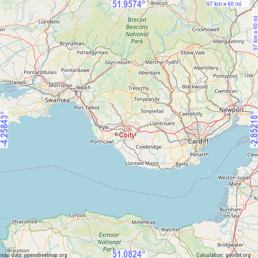
Coity GPS coordinates[2]
51° 31' 19.2" North, 3° 33' 19.116" West
| Map corner | latitude | longitude |
|---|---|---|
| Upper-left | 51.9574°, | -4.25843° |
| Center: | 51.522°, | -3.55531° |
| Lower-right: | 51.0824°, | -2.85218° |
| Map W x H: | 97.3×97.3 km | = 60.5×60.5mi |
| max Lat: | 60.39635° ⇑77% North |
| Coity: | 51.522° |
| min Lat: | ⇓23% South 34.60088° |
| min Long | Coity | max Long |
| -7.64133° | -3.55531° | 32.95536° |
| W 16.9%⇐ | ⇒83.1% E |
Elevation
Elevation of Coity is 64 m = 210 ft, and this is 8.9 m = 29 ft below average elevation for this country.
| Max E: |
515 m = 1690 ft | 47.6% |
| Avg. | 72.9 m = 239 ft | |
| Coity | 64 m = 210 ft | |
Min E: |
-30 m = -98 ft | 52.4% |
See also: Coity elevation on elevation.city.
Geographical zone
Coity is located in North temperate zone (between Tropic of Cancer and the Arctic Circle). Distance of this North polar circle is 1672.5 km =1039.2 mi to North.| Distance of | km | miles | from Coity |
|---|---|---|---|
| North Pole | 4278.4 | 2658.5 | to North |
| Arctic Circle | 1672.5 | 1039.2 | to North |
| Tropic Cancer | 3122.8 | 1940.4 | to South |
| Equator | 5728.7 | 3559.6 | to South |


Nearby cities:
15 places around Coity: (largest is in red/bold)
• Aberkenfig
3.4 km =2.1 mi,  305°
305°
• Betws
5.7 km =3.5 mi,  336°
336°
• Blackmill
5.3 km =3.3 mi,  12°
12°
• Bridgend
2.4 km =1.5 mi,  220°
220°
• Brynna
6.6 km =4.1 mi,  73°
73°
• Cefn Cribwr
6.8 km =4.2 mi,  279°
279°
• Ewenny
4.6 km =2.9 mi,  195°
195°
• Heol-y-Cyw
3.6 km =2.2 mi,  38°
38°
• Llangan
5.4 km =3.4 mi,  135°
135°
• Llangeinor
6 km =3.7 mi,  350°
350°
• Llanharan
8.2 km =5.1 mi,  77°
77°
• Llanharry
8.5 km =5.3 mi,  95°
95°
• Merthyr Mawr
5.4 km =3.4 mi, 222°
• Pencoed
3.8 km =2.4 mi,  87°
87°
• Penllyn
7.5 km =4.7 mi,  134°
134°
Sources, notices
• [Note1] Compared only with cities in United Kingdom existing in our database
• [Src1] Map data: © OpenStreetMap contributors (CC-BY-SA)
• [Src2] Other city data from geonames.org with taken over terms of usage.
• [Src3] Geographical zone / Annual Mean Temperature by Robert A. Rohde @ Wikipedia
