Bridgend geodata
Bridgend (Wales) is a seat of a second-order administrative division; located in United Kingdom in Europe/London (GMT+0) time zone. With population of 58,380 people, there are 193 cities with bigger population in this country. Compared to other cities in United Kingdom, 77.5% of cities are located further ↑North; 83.3% of cities are located further →East and 77.8% of cities have higher elevation than Bridgend. Note1


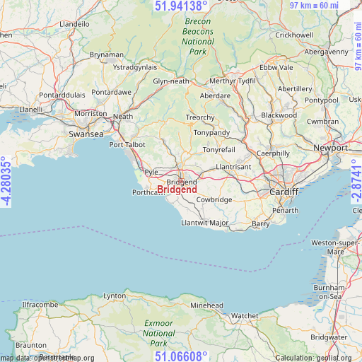
Bridgend GPS coordinates[2]
51° 30' 20.988" North, 3° 34' 37.992" West
| Map corner | latitude | longitude |
|---|---|---|
| Upper-left | 51.94138°, | -4.28035° |
| Center: | 51.50583°, | -3.57722° |
| Lower-right: | 51.06608°, | -2.8741° |
| Map W x H: | 97.3×97.3 km | = 60.5×60.5mi |
| max Lat: | 60.39635° ⇑77.5% North |
| Bridgend: | 51.50583° |
| min Lat: | ⇓22.5% South 34.60088° |
| min Long | Bridgend | max Long |
| -7.64133° | -3.57722° | 32.95536° |
| W 16.7%⇐ | ⇒83.3% E |
Elevation
Elevation of Bridgend is 23 m = 75 ft, and this is 49.9 m = 164 ft below average elevation for this country.
| Max E: |
515 m = 1690 ft | 77.8% |
| Avg. | 72.9 m = 239 ft | |
| Bridgend | 23 m = 75 ft | |
Min E: |
-30 m = -98 ft | 22.2% |
See also: Bridgend elevation on elevation.city.
Geographical zone
Bridgend is located in North temperate zone (between Tropic of Cancer and the Arctic Circle). Distance of this North polar circle is 1674.3 km =1040.4 mi to North.| Distance of | km | miles | from Bridgend |
|---|---|---|---|
| North Pole | 4280.2 | 2659.6 | to North |
| Arctic Circle | 1674.3 | 1040.4 | to North |
| Tropic Cancer | 3121 | 1939.3 | to South |
| Equator | 5726.9 | 3558.5 | to South |


Nearby cities:
15 places around Bridgend: (largest is in red/bold)
• Aberkenfig
4 km =2.5 mi,  341°
341°
• Betws
7.1 km =4.4 mi,  353°
353°
• Blackmill
7.4 km =4.6 mi,  20°
20°
• Brynna
8.6 km =5.3 mi,  65°
65°
• Cefn Cribwr
6 km =3.7 mi,  298°
298°
• Coity
2.4 km =1.5 mi,  40°
40°
• Ewenny
2.7 km =1.7 mi,  174°
174°
• Heol-y-Cyw
6 km =3.7 mi, 39°
• Llangan
5.7 km =3.5 mi,  111°
111°
• Llangeinor
7.8 km =4.8 mi,  4°
4°
• Merthyr Mawr
3.1 km =1.9 mi,  224°
224°
• Ogmore-by-Sea
6.2 km =3.9 mi, 216°
• Pencoed
5.7 km =3.5 mi, 69°
• Penllyn
7.7 km =4.8 mi,  117°
117°
• Wick
7.6 km =4.7 mi, 165°
Sources, notices
• [Note1] Compared only with cities in United Kingdom existing in our database
• [Src1] Map data: © OpenStreetMap contributors (CC-BY-SA)
• [Src2] Other city data from geonames.org with taken over terms of usage.
• [Src3] Geographical zone / Annual Mean Temperature by Robert A. Rohde @ Wikipedia
