Brora geodata
Brora (Scotland) is a populated place; located in United Kingdom in Europe/London (GMT+0) time zone. With population of 1,290 people, there are 3256 cities with bigger population in this country. Compared to other cities in United Kingdom, 99.7% of cities are located further ↓South; 86.4% of cities are located further →East and 82.8% of cities have higher elevation than Brora. Note1


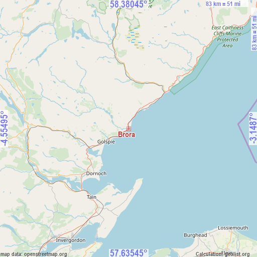
Brora GPS coordinates[2]
58° 0' 35.604" North, 3° 51' 6.552" West
| Map corner | latitude | longitude |
|---|---|---|
| Upper-left | 58.38045°, | -4.55495° |
| Center: | 58.00989°, | -3.85182° |
| Lower-right: | 57.63545°, | -3.1487° |
| Map W x H: | 82.8×82.8 km | = 51.4×51.4mi |
| max Lat: | 60.39635° ⇑0.3% North |
| Brora: | 58.00989° |
| min Lat: | ⇓99.7% South 34.60088° |
| min Long | Brora | max Long |
| -7.64133° | -3.85182° | 32.95536° |
| W 13.6%⇐ | ⇒86.4% E |
Elevation
Elevation of Brora is 18 m = 59 ft, and this is 54.9 m = 180 ft below average elevation for this country.
| Max E: |
515 m = 1690 ft | 82.8% |
| Avg. | 72.9 m = 239 ft | |
| Brora | 18 m = 59 ft | |
Min E: |
-30 m = -98 ft | 17.2% |
See also: United Kingdom elevation on elevation.city.
Geographical zone
Brora is located in North temperate zone (between Tropic of Cancer and the Arctic Circle). Distance of this North polar circle is 951.1 km =591 mi to North.| Distance of | km | miles | from Brora |
|---|---|---|---|
| North Pole | 3557 | 2210.2 | to North |
| Arctic Circle | 951.1 | 591 | to North |
| Tropic Cancer | 3844.2 | 2388.7 | to South |
| Equator | 6450.1 | 4007.9 | to South |


Nearby cities:
15 places around Brora: (largest is in red/bold)
• Alness
42.3 km =26.3 mi,  214°
214°
• Balintore
28.5 km =17.7 mi,  187°
187°
• Burghead
40.5 km =25.2 mi,  148°
148°
• Cromarty
38.1 km =23.7 mi,  196°
196°
• Dornoch
17.8 km =11.1 mi,  215°
215°
• Findhorn
41.8 km =26 mi,  159°
159°
• Forres
46.5 km =28.9 mi, 162°
• Golspie
8.5 km =5.3 mi,  240°
240°
• Helmsdale
16.7 km =10.4 mi,  44°
44°
• Hopeman
42 km =26.1 mi,  143°
143°
• Invergordon
40.3 km =25 mi, 207°
• Kinloss
44.9 km =27.9 mi, 158°
• Lossiemouth
46.5 km =28.9 mi,  133°
133°
• Nairn
47.7 km =29.6 mi,  181°
181°
• Tain
25.5 km =15.8 mi, 208°
Sources, notices
• [Note1] Compared only with cities in United Kingdom existing in our database
• [Src1] Map data: © OpenStreetMap contributors (CC-BY-SA)
• [Src2] Other city data from geonames.org with taken over terms of usage.
• [Src3] Geographical zone / Annual Mean Temperature by Robert A. Rohde @ Wikipedia
