Broadford geodata
Broadford (Scotland) is a populated place; located in United Kingdom in Europe/London (GMT+1) time zone. With population of 760 people, there are 4115 cities with bigger population in this country. Compared to other cities in United Kingdom, 97.9% of cities are located further ↓South; 98.3% of cities are located further →East and 96.2% of cities have higher elevation than Broadford. Note1


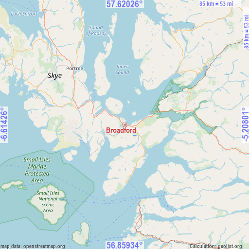
Broadford GPS coordinates[2]
57° 14' 30.336" North, 5° 54' 40.104" West
| Map corner | latitude | longitude |
|---|---|---|
| Upper-left | 57.62026°, | -6.61426° |
| Center: | 57.24176°, | -5.91114° |
| Lower-right: | 56.85934°, | -5.20801° |
| Map W x H: | 84.6×84.6 km | = 52.6×52.6mi |
| max Lat: | 60.39635° ⇑2.1% North |
| Broadford: | 57.24176° |
| min Lat: | ⇓97.9% South 34.60088° |
| min Long | Broadford | max Long |
| -7.64133° | -5.91114° | 32.95536° |
| W 1.7%⇐ | ⇒98.3% E |
Elevation
Elevation of Broadford is 7 m = 23 ft, and this is 65.9 m = 216 ft below average elevation for this country.
| Max E: |
515 m = 1690 ft | 96.2% |
| Avg. | 72.9 m = 239 ft | |
| Broadford | 7 m = 23 ft | |
Min E: |
-30 m = -98 ft | 3.8% |
See also: United Kingdom elevation on elevation.city.
Geographical zone
Broadford is located in North temperate zone (between Tropic of Cancer and the Arctic Circle). Distance of this North polar circle is 1036.5 km =644.1 mi to North.| Distance of | km | miles | from Broadford |
|---|---|---|---|
| North Pole | 3642.4 | 2263.3 | to North |
| Arctic Circle | 1036.5 | 644.1 | to North |
| Tropic Cancer | 3758.8 | 2335.6 | to South |
| Equator | 6364.7 | 3954.8 | to South |


Nearby cities:
15 places around Broadford: (largest is in red/bold)
• Ballachulish
78.5 km =48.8 mi,  143°
143°
• Caol
66.5 km =41.3 mi,  132°
132°
• Drumnadrochit
86.6 km =53.8 mi,  83°
83°
• Fort Augustus
74.8 km =46.5 mi,  98°
98°
• Fort William
67.6 km =42 mi, 134°
• Isle Of Mull
88.8 km =55.2 mi,  174°
174°
• Isle of South Uist
85.6 km =53.2 mi,  270°
270°
• Kinlochleven
81.9 km =50.9 mi, 136°
• Kyle of Lochalsh
12.9 km =8 mi,  68°
68°
• Mallaig
27 km =16.8 mi, 169°
• Milton
85.2 km =52.9 mi, 82°
• Portree
25.5 km =15.8 mi,  318°
318°
• Spean Bridge
71.5 km =44.4 mi,  123°
123°
• Tobermory
69.6 km =43.2 mi,  188°
188°
• Ullapool
85.7 km =53.3 mi,  31°
31°
Sources, notices
• [Note1] Compared only with cities in United Kingdom existing in our database
• [Src1] Map data: © OpenStreetMap contributors (CC-BY-SA)
• [Src2] Other city data from geonames.org with taken over terms of usage.
• [Src3] Geographical zone / Annual Mean Temperature by Robert A. Rohde @ Wikipedia
