Bristol geodata
Bristol (England) is a seat of a second-order administrative division; located in United Kingdom in Europe/London (GMT+0) time zone. With population of 617,280 people, there are 5 cities with bigger population in this country. Compared to other cities in United Kingdom, 79.2% of cities are located further ↑North; 67% of cities are located further →East and 79.9% of cities have higher elevation than Bristol. Note1


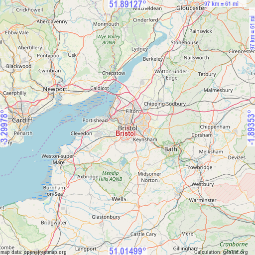
Bristol GPS coordinates[2]
51° 27' 18.828" North, 2° 35' 47.94" West
| Map corner | latitude | longitude |
|---|---|---|
| Upper-left | 51.89127°, | -3.29978° |
| Center: | 51.45523°, | -2.59665° |
| Lower-right: | 51.01499°, | -1.89353° |
| Map W x H: | 97.4×97.4 km | = 60.5×60.5mi |
| max Lat: | 60.39635° ⇑79.2% North |
| Bristol: | 51.45523° |
| min Lat: | ⇓20.8% South 34.60088° |
| min Long | Bristol | max Long |
| -7.64133° | -2.59665° | 32.95536° |
| W 33%⇐ | ⇒67% E |
Elevation
Elevation of Bristol is 21 m = 69 ft, and this is 51.9 m = 170 ft below average elevation for this country.
| Max E: |
515 m = 1690 ft | 79.9% |
| Avg. | 72.9 m = 239 ft | |
| Bristol | 21 m = 69 ft | |
Min E: |
-30 m = -98 ft | 20.1% |
See also: Bristol elevation on elevation.city.
Geographical zone
Bristol is located in North temperate zone (between Tropic of Cancer and the Arctic Circle). Distance of this North polar circle is 1679.9 km =1043.8 mi to North.| Distance of | km | miles | from Bristol |
|---|---|---|---|
| North Pole | 4285.8 | 2663.1 | to North |
| Arctic Circle | 1679.9 | 1043.8 | to North |
| Tropic Cancer | 3115.4 | 1935.8 | to South |
| Equator | 5721.3 | 3555 | to South |


Nearby cities:
15 places around Bristol: (largest is in red/bold)
• Bishopsworth
4.8 km =3 mi,  200°
200°
• Dundry
6.9 km =4.3 mi,  205°
205°
• Easton-in-Gordano
7.5 km =4.7 mi,  287°
287°
• Failand
6.6 km =4.1 mi,  255°
255°
• Felton
9.5 km =5.9 mi,  218°
218°
• Keynsham
8.3 km =5.2 mi,  123°
123°
• Kingswood
6.1 km =3.8 mi,  92°
92°
• Long Ashton
5.3 km =3.3 mi,  237°
237°
• Mangotsfield
7.4 km =4.6 mi,  60°
60°
• Publow
9.3 km =5.8 mi,  156°
156°
• Stanton Drew
9.8 km =6.1 mi,  175°
175°
• Stoke Gifford
7.9 km =4.9 mi,  29°
29°
• Whitchurch
6 km =3.7 mi, 156°
• Winford
9.2 km =5.7 mi, 209°
• Winterbourne
9.9 km =6.2 mi,  40°
40°
Sources, notices
• [Note1] Compared only with cities in United Kingdom existing in our database
• [Src1] Map data: © OpenStreetMap contributors (CC-BY-SA)
• [Src2] Other city data from geonames.org with taken over terms of usage.
• [Src3] Geographical zone / Annual Mean Temperature by Robert A. Rohde @ Wikipedia
