Brent geodata
Brent (England) is a section of populated place; located in United Kingdom in Europe/London (GMT+1) time zone. With population of 329,100 people, there are 15 cities with bigger population in this country. Compared to other cities in United Kingdom, 75.9% of cities are located further ↑North; 80.9% of cities are located further ←West and 61.7% of cities have higher elevation than Brent. Note1


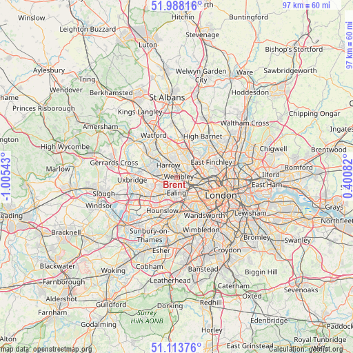
Brent GPS coordinates[2]
51° 33' 11.016" North, 0° 18' 8.28" West
| Map corner | latitude | longitude |
|---|---|---|
| Upper-left | 51.98816°, | -1.00543° |
| Center: | 51.55306°, | -0.3023° |
| Lower-right: | 51.11376°, | 0.40082° |
| Map W x H: | 97.2×97.2 km | = 60.4×60.4mi |
| max Lat: | 60.39635° ⇑75.9% North |
| Brent: | 51.55306° |
| min Lat: | ⇓24.1% South 34.60088° |
| min Long | Brent | max Long |
| -7.64133° | -0.3023° | 32.95536° |
| W 80.9%⇐ | ⇒19.1% E |
Elevation
Elevation of Brent is 44 m = 144 ft, and this is 28.9 m = 95 ft below average elevation for this country.
| Max E: |
515 m = 1690 ft | 61.7% |
| Avg. | 72.9 m = 239 ft | |
| Brent | 44 m = 144 ft | |
Min E: |
-30 m = -98 ft | 38.3% |
See also: Brent elevation on elevation.city.
Geographical zone
Brent is located in North temperate zone (between Tropic of Cancer and the Arctic Circle). Distance of this North polar circle is 1669 km =1037.1 mi to North.| Distance of | km | miles | from Brent |
|---|---|---|---|
| North Pole | 4274.9 | 2656.3 | to North |
| Arctic Circle | 1669 | 1037.1 | to North |
| Tropic Cancer | 3126.2 | 1942.5 | to South |
| Equator | 5732.2 | 3561.8 | to South |


Nearby cities:
15 places around Brent: (largest is in red/bold)
• Acton
5.2 km =3.2 mi,  159°
159°
• Brentford
7.4 km =4.6 mi,  183°
183°
• Ealing
4.5 km =2.8 mi, 179°
• Ealing Broadway
4.2 km =2.6 mi, 178°
• Edgware
6.9 km =4.3 mi,  15°
15°
• Greenford
4.5 km =2.8 mi,  233°
233°
• Greenhill
4.2 km =2.6 mi,  323°
323°
• Harrow
3.5 km =2.2 mi, 323°
• Harrow on the Hill
3 km =1.9 mi,  313°
313°
• Hendon
7.9 km =4.9 mi,  48°
48°
• Northolt
4.6 km =2.9 mi,  263°
263°
• Pinner
7.1 km =4.4 mi, 309°
• Southall
6.8 km =4.2 mi,  224°
224°
• Stanmore
7.1 km =4.4 mi,  352°
352°
• Wembley
0.4 km =0.2 mi,  100°
100°
Sources, notices
• [Note1] Compared only with cities in United Kingdom existing in our database
• [Src1] Map data: © OpenStreetMap contributors (CC-BY-SA)
• [Src2] Other city data from geonames.org with taken over terms of usage.
• [Src3] Geographical zone / Annual Mean Temperature by Robert A. Rohde @ Wikipedia
