Bradworthy geodata
Bradworthy (England) is a populated place; located in United Kingdom in Europe/London (GMT+0) time zone. With population of 650 people, there are 4413 cities with bigger population in this country. Compared to other cities in United Kingdom, 93.3% of cities are located further ↑North; 92.2% of cities are located further →East and 94.6% of cities have lower elevation than Bradworthy. Note1
Administrative division(s):
- Level 1: England
- Level 2: Devon
- Level 3: Torridge District
- Level 4: Bradworthy


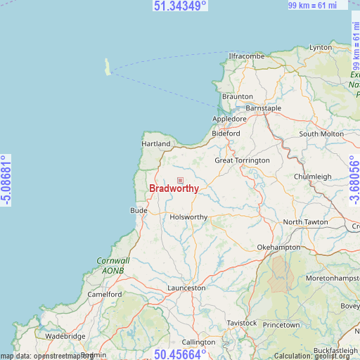
Bradworthy GPS coordinates[2]
50° 54' 7.848" North, 4° 23' 1.248" West
| Map corner | latitude | longitude |
|---|---|---|
| Upper-left | 51.34349°, | -5.08681° |
| Center: | 50.90218°, | -4.38368° |
| Lower-right: | 50.45664°, | -3.68056° |
| Map W x H: | 98.6×98.6 km | = 61.3×61.3mi |
| max Lat: | 60.39635° ⇑93.3% North |
| Bradworthy: | 50.90218° |
| min Lat: | ⇓6.7% South 34.60088° |
| min Long | Bradworthy | max Long |
| -7.64133° | -4.38368° | 32.95536° |
| W 7.8%⇐ | ⇒92.2% E |
Elevation
Elevation of Bradworthy is 180 m = 591 ft, and this is 107.1 m = 351 ft above average elevation for this country.
| Max E: |
515 m = 1690 ft | 5.4% |
| Bradworthy | 180 m 591 ft | |
| Avg. | 72.9 m = 239 ft | |
Min E: |
-30 m = -98 ft | 94.6% |
See also: United Kingdom elevation on elevation.city.
Geographical zone
Bradworthy is located in North temperate zone (between Tropic of Cancer and the Arctic Circle). Distance of this North polar circle is 1741.4 km =1082.1 mi to North.| Distance of | km | miles | from Bradworthy |
|---|---|---|---|
| North Pole | 4347.3 | 2701.3 | to North |
| Arctic Circle | 1741.4 | 1082.1 | to North |
| Tropic Cancer | 3053.9 | 1897.6 | to South |
| Equator | 5659.8 | 3516.8 | to South |


Nearby cities:
15 places around Bradworthy: (largest is in red/bold)
• Appledore
20.9 km =13 mi,  38°
38°
• Bideford
17.7 km =11 mi, 43°
• Bude
14 km =8.7 mi,  231°
231°
• Flexbury
13.6 km =8.5 mi,  236°
236°
• Great Torrington
17.7 km =11 mi,  71°
71°
• Hartland
12.2 km =7.6 mi,  326°
326°
• Holsworthy
10.2 km =6.3 mi,  168°
168°
• Kilkhampton
7.6 km =4.7 mi,  247°
247°
• Marhamchurch
14.5 km =9 mi,  222°
222°
• Merton
20 km =12.4 mi,  96°
96°
• Northam
18.7 km =11.6 mi, 38°
• Poughill
12 km =7.5 mi, 236°
• Poundstock
19.1 km =11.9 mi, 217°
• Shebbear
12.7 km =7.9 mi,  110°
110°
• Woolfardisworthy
7 km =4.3 mi,  3°
3°
Sources, notices
• [Note1] Compared only with cities in United Kingdom existing in our database
• [Src1] Map data: © OpenStreetMap contributors (CC-BY-SA)
• [Src2] Other city data from geonames.org with taken over terms of usage.
• [Src3] Geographical zone / Annual Mean Temperature by Robert A. Rohde @ Wikipedia
