Bow Street geodata
Bow Street (Wales) is a populated place; located in United Kingdom in Europe/London (GMT+1) time zone. With population of 1,572 people, there are 2978 cities with bigger population in this country. Compared to other cities in United Kingdom, 51% of cities are located further ↑North; 88.2% of cities are located further →East and 73.1% of cities have higher elevation than Bow Street. Note1


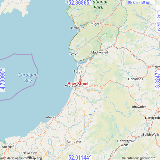
Bow Street GPS coordinates[2]
52° 26' 31.668" North, 4° 1' 40.188" West
| Map corner | latitude | longitude |
|---|---|---|
| Upper-left | 52.86865°, | -4.73095° |
| Center: | 52.44213°, | -4.02783° |
| Lower-right: | 52.01144°, | -3.3247° |
| Map W x H: | 95.3×95.3 km | = 59.2×59.2mi |
| max Lat: | 60.39635° ⇑51% North |
| Bow Street: | 52.44213° |
| min Lat: | ⇓49% South 34.60088° |
| min Long | Bow Street | max Long |
| -7.64133° | -4.02783° | 32.95536° |
| W 11.8%⇐ | ⇒88.2% E |
Elevation
Elevation of Bow Street is 29 m = 95 ft, and this is 43.9 m = 144 ft below average elevation for this country.
| Max E: |
515 m = 1690 ft | 73.1% |
| Avg. | 72.9 m = 239 ft | |
| Bow Street | 29 m = 95 ft | |
Min E: |
-30 m = -98 ft | 26.9% |
See also: United Kingdom elevation on elevation.city.
Geographical zone
Bow Street is located in North temperate zone (between Tropic of Cancer and the Arctic Circle). Distance of this North polar circle is 1570.2 km =975.7 mi to North.| Distance of | km | miles | from Bow Street |
|---|---|---|---|
| North Pole | 4176 | 2594.8 | to North |
| Arctic Circle | 1570.2 | 975.7 | to North |
| Tropic Cancer | 3225.1 | 2004 | to South |
| Equator | 5831 | 3623.2 | to South |


Nearby cities:
15 places around Bow Street: (largest is in red/bold)
• Aberaeron
27.2 km =16.9 mi,  215°
215°
• Aberdyfi
11.4 km =7.1 mi,  353°
353°
• Aberystwyth
4.8 km =3 mi,  231°
231°
• Borth
5.4 km =3.4 mi,  343°
343°
• Corris
26.4 km =16.4 mi,  28°
28°
• Llan-non
20.5 km =12.7 mi,  209°
209°
• Llanilar
9.5 km =5.9 mi,  179°
179°
• Llanrhystud
17.1 km =10.6 mi, 207°
• Lledrod
16.1 km =10 mi,  169°
169°
• Llwyngwril
25.4 km =15.8 mi, 351°
• Machynlleth
20.4 km =12.7 mi,  35°
35°
• Penparcau
5.3 km =3.3 mi, 216°
• Pontrhydfendigaid
21 km =13 mi,  147°
147°
• Tregaron
25.6 km =15.9 mi, 165°
• Tywyn
16.6 km =10.3 mi, 344°
Sources, notices
• [Note1] Compared only with cities in United Kingdom existing in our database
• [Src1] Map data: © OpenStreetMap contributors (CC-BY-SA)
• [Src2] Other city data from geonames.org with taken over terms of usage.
• [Src3] Geographical zone / Annual Mean Temperature by Robert A. Rohde @ Wikipedia
