Penparcau geodata
Penparcau (Wales) is a populated place; located in United Kingdom in Europe/London (GMT+1) time zone. With population of 3,088 people, there are 2091 cities with bigger population in this country. Compared to other cities in United Kingdom, 51.7% of cities are located further ↑North; 88.9% of cities are located further →East and 77.8% of cities have higher elevation than Penparcau. Note1


Penparcau GPS coordinates[2]
52° 24' 11.988" North, 4° 4' 27.012" West
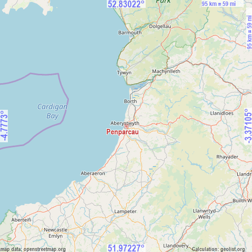
| Map corner | latitude | longitude |
|---|---|---|
| Upper-left | 52.83022°, | -4.7773° |
| Center: | 52.40333°, | -4.07417° |
| Lower-right: | 51.97227°, | -3.37105° |
| Map W x H: | 95.4×95.4 km | = 59.3×59.3mi |
| max Lat: | 60.39635° ⇑51.7% North |
| Penparcau: | 52.40333° |
| min Lat: | ⇓48.3% South 34.60088° |
| min Long | Penparcau | max Long |
| -7.64133° | -4.07417° | 32.95536° |
| W 11.1%⇐ | ⇒88.9% E |
Elevation
Elevation of Penparcau is 23 m = 75 ft, and this is 49.9 m = 164 ft below average elevation for this country.
| Max E: |
515 m = 1690 ft | 77.8% |
| Avg. | 72.9 m = 239 ft | |
| Penparcau | 23 m = 75 ft | |
Min E: |
-30 m = -98 ft | 22.2% |
See also: United Kingdom elevation on elevation.city.
Geographical zone
Penparcau is located in North temperate zone (between Tropic of Cancer and the Arctic Circle). Distance of this North polar circle is 1574.5 km =978.3 mi to North.| Distance of | km | miles | from Penparcau |
|---|---|---|---|
| North Pole | 4180.4 | 2597.6 | to North |
| Arctic Circle | 1574.5 | 978.3 | to North |
| Tropic Cancer | 3220.8 | 2001.3 | to South |
| Equator | 5826.7 | 3620.5 | to South |


Nearby cities:
15 places around Penparcau: (largest is in red/bold)
• Aberaeron
21.8 km =13.5 mi,  215°
215°
• Aberdyfi
15.8 km =9.8 mi,  6°
6°
• Aberystwyth
1.5 km =0.9 mi,  336°
336°
• Borth
9.6 km =6 mi, 9°
• Bow Street
5.3 km =3.3 mi,  36°
36°
• Henfynyw Upper
24 km =14.9 mi,  213°
213°
• Llan-non
15.2 km =9.4 mi, 207°
• Llangybi
28.2 km =17.5 mi,  176°
176°
• Llanilar
6.2 km =3.9 mi,  147°
147°
• Llanrhystud
11.8 km =7.3 mi,  203°
203°
• Lledrod
13 km =8.1 mi, 151°
• Machynlleth
25.8 km =16 mi, 35°
• Pontrhydfendigaid
19.6 km =12.2 mi,  133°
133°
• Tregaron
22.6 km =14 mi, 154°
• Tywyn
20.3 km =12.6 mi,  356°
356°
Sources, notices
• [Note1] Compared only with cities in United Kingdom existing in our database
• [Src1] Map data: © OpenStreetMap contributors (CC-BY-SA)
• [Src2] Other city data from geonames.org with taken over terms of usage.
• [Src3] Geographical zone / Annual Mean Temperature by Robert A. Rohde @ Wikipedia
