Lledrod geodata
Lledrod (Wales) is a seat of a third-order administrative division; located in United Kingdom in Europe/London (GMT+1) time zone. In our database, there are 4977 cities with bigger population. Compared to other cities in United Kingdom, 54.1% of cities are located further ↑North; 87.8% of cities are located further →East and 96.8% of cities have lower elevation than Lledrod. Note1


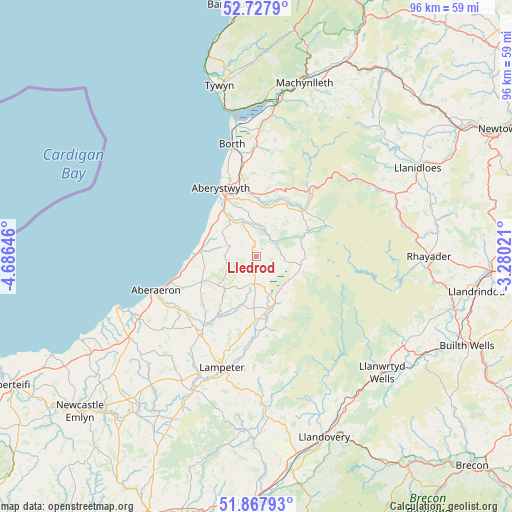
Lledrod GPS coordinates[2]
52° 18' 0" North, 3° 58' 59.988" West
| Map corner | latitude | longitude |
|---|---|---|
| Upper-left | 52.7279°, | -4.68646° |
| Center: | 52.3°, | -3.98333° |
| Lower-right: | 51.86793°, | -3.28021° |
| Map W x H: | 95.6×95.6 km | = 59.4×59.4mi |
| max Lat: | 60.39635° ⇑54.1% North |
| Lledrod: | 52.3° |
| min Lat: | ⇓45.9% South 34.60088° |
| min Long | Lledrod | max Long |
| -7.64133° | -3.98333° | 32.95536° |
| W 12.2%⇐ | ⇒87.8% E |
Elevation
Elevation of Lledrod is 204 m = 669 ft, and this is 131.1 m = 430 ft above average elevation for this country.
| Max E: |
515 m = 1690 ft | 3.2% |
| Lledrod | 204 m 669 ft | |
| Avg. | 72.9 m = 239 ft | |
Min E: |
-30 m = -98 ft | 96.8% |
See also: United Kingdom elevation on elevation.city.
Geographical zone
Lledrod is located in North temperate zone (between Tropic of Cancer and the Arctic Circle). Distance of this North polar circle is 1586 km =985.5 mi to North.| Distance of | km | miles | from Lledrod |
|---|---|---|---|
| North Pole | 4191.8 | 2604.7 | to North |
| Arctic Circle | 1586 | 985.5 | to North |
| Tropic Cancer | 3209.3 | 1994.2 | to South |
| Equator | 5815.2 | 3613.4 | to South |


Nearby cities:
15 places around Lledrod: (largest is in red/bold)
• Aberaeron
19.8 km =12.3 mi,  251°
251°
• Aberystwyth
14.5 km =9 mi,  332°
332°
• Borth
21.5 km =13.4 mi,  347°
347°
• Bow Street
16.1 km =10 mi, 349°
• Cwmann
22.6 km =14 mi,  193°
193°
• Henfynyw Upper
21.4 km =13.3 mi, 246°
• Lampeter
21.8 km =13.5 mi,  197°
197°
• Llan-non
13.3 km =8.3 mi,  261°
261°
• Llanarth
25 km =15.5 mi,  241°
241°
• Llangybi
17.3 km =10.7 mi, 195°
• Llanilar
6.9 km =4.3 mi,  335°
335°
• Llanrhystud
11 km =6.8 mi,  273°
273°
• Penparcau
13 km =8.1 mi, 331°
• Pontrhydfendigaid
8.4 km =5.2 mi,  103°
103°
• Tregaron
9.6 km =6 mi,  159°
159°
Sources, notices
• [Note1] Compared only with cities in United Kingdom existing in our database
• [Src1] Map data: © OpenStreetMap contributors (CC-BY-SA)
• [Src2] Other city data from geonames.org with taken over terms of usage.
• [Src3] Geographical zone / Annual Mean Temperature by Robert A. Rohde @ Wikipedia
