Bottesford geodata
Bottesford (England) is a populated place; located in United Kingdom in Europe/London (GMT+1) time zone. With population of 3,348 people, there are 2017 cities with bigger population in this country. Compared to other cities in United Kingdom, 59.7% of cities are located further ↓South; 70.3% of cities are located further ←West and 68.3% of cities have higher elevation than Bottesford. Note1
Administrative division(s):
- Level 1: England
- Level 2: Leicestershire
- Level 3: Melton District
- Level 4: Bottesford


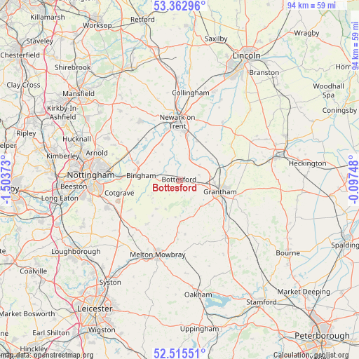
Bottesford GPS coordinates[2]
52° 56' 28.716" North, 0° 48' 2.16" West
| Map corner | latitude | longitude |
|---|---|---|
| Upper-left | 53.36296°, | -1.50373° |
| Center: | 52.94131°, | -0.8006° |
| Lower-right: | 52.51551°, | -0.09748° |
| Map W x H: | 94.2×94.2 km | = 58.5×58.5mi |
| max Lat: | 60.39635° ⇑40.3% North |
| Bottesford: | 52.94131° |
| min Lat: | ⇓59.7% South 34.60088° |
| min Long | Bottesford | max Long |
| -7.64133° | -0.8006° | 32.95536° |
| W 70.3%⇐ | ⇒29.7% E |
Elevation
Elevation of Bottesford is 35 m = 115 ft, and this is 37.9 m = 124 ft below average elevation for this country.
| Max E: |
515 m = 1690 ft | 68.3% |
| Avg. | 72.9 m = 239 ft | |
| Bottesford | 35 m = 115 ft | |
Min E: |
-30 m = -98 ft | 31.7% |
See also: United Kingdom elevation on elevation.city.
Geographical zone
Bottesford is located in North temperate zone (between Tropic of Cancer and the Arctic Circle). Distance of this North polar circle is 1514.7 km =941.2 mi to North.| Distance of | km | miles | from Bottesford |
|---|---|---|---|
| North Pole | 4120.5 | 2560.4 | to North |
| Arctic Circle | 1514.7 | 941.2 | to North |
| Tropic Cancer | 3280.6 | 2038.5 | to South |
| Equator | 5886.5 | 3657.7 | to South |


Nearby cities:
15 places around Bottesford: (largest is in red/bold)
• Allington
5.2 km =3.2 mi,  75°
75°
• Aslockton
6.6 km =4.1 mi,  281°
281°
• Barrowby
7.9 km =4.9 mi,  110°
110°
• Bingham
10.7 km =6.6 mi, 275°
• Claypole
11 km =6.8 mi,  23°
23°
• Croxton Kerrial
9.9 km =6.2 mi,  164°
164°
• East Bridgford
11.8 km =7.3 mi,  291°
291°
• Elston
10.3 km =6.4 mi,  333°
333°
• Grantham
11.1 km =6.9 mi, 107°
• Great Gonerby
9 km =5.6 mi,  94°
94°
• Harby
9.9 km =6.2 mi,  220°
220°
• Harlaxton
9.8 km =6.1 mi,  129°
129°
• Hose
11.7 km =7.3 mi, 216°
• Long Bennington
6.4 km =4 mi,  26°
26°
• Stathern
8.5 km =5.3 mi,  205°
205°
Sources, notices
• [Note1] Compared only with cities in United Kingdom existing in our database
• [Src1] Map data: © OpenStreetMap contributors (CC-BY-SA)
• [Src2] Other city data from geonames.org with taken over terms of usage.
• [Src3] Geographical zone / Annual Mean Temperature by Robert A. Rohde @ Wikipedia
