Grantham geodata
Grantham (England) is a populated place; located in United Kingdom in Europe/London (GMT+0) time zone. With population of 43,833 people, there are 269 cities with bigger population in this country. Compared to other cities in United Kingdom, 59.3% of cities are located further ↓South; 73.6% of cities are located further ←West and 52.4% of cities have lower elevation than Grantham. Note1


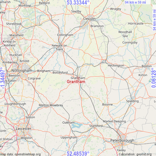
Grantham GPS coordinates[2]
52° 54' 41.364" North, 0° 38' 30.624" West
| Map corner | latitude | longitude |
|---|---|---|
| Upper-left | 53.33344°, | -1.34497° |
| Center: | 52.91149°, | -0.64184° |
| Lower-right: | 52.48539°, | 0.06128° |
| Map W x H: | 94.3×94.3 km | = 58.6×58.6mi |
| max Lat: | 60.39635° ⇑40.7% North |
| Grantham: | 52.91149° |
| min Lat: | ⇓59.3% South 34.60088° |
| min Long | Grantham | max Long |
| -7.64133° | -0.64184° | 32.95536° |
| W 73.6%⇐ | ⇒26.4% E |
Elevation
Elevation of Grantham is 64 m = 210 ft, and this is 8.9 m = 29 ft below average elevation for this country.
| Max E: |
515 m = 1690 ft | 47.6% |
| Avg. | 72.9 m = 239 ft | |
| Grantham | 64 m = 210 ft | |
Min E: |
-30 m = -98 ft | 52.4% |
See also: Grantham elevation on elevation.city.
Geographical zone
Grantham is located in North temperate zone (between Tropic of Cancer and the Arctic Circle). Distance of this North polar circle is 1518 km =943.2 mi to North.| Distance of | km | miles | from Grantham |
|---|---|---|---|
| North Pole | 4123.9 | 2562.5 | to North |
| Arctic Circle | 1518 | 943.2 | to North |
| Tropic Cancer | 3277.3 | 2036.4 | to South |
| Equator | 5883.2 | 3655.6 | to South |


Nearby cities:
15 places around Grantham: (largest is in red/bold)
• Allington
7.3 km =4.5 mi,  309°
309°
• Ancaster
10.6 km =6.6 mi,  41°
41°
• Barrowby
3.3 km =2.1 mi,  279°
279°
• Bottesford
11.1 km =6.9 mi,  287°
287°
• Caythorpe
12 km =7.5 mi,  13°
13°
• Claypole
14.7 km =9.1 mi,  335°
335°
• Colsterworth
11.7 km =7.3 mi,  173°
173°
• Corby Glen
13.8 km =8.6 mi,  142°
142°
• Croxton Kerrial
10.2 km =6.3 mi,  231°
231°
• Great Gonerby
3.1 km =1.9 mi,  327°
327°
• Harlaxton
4.3 km =2.7 mi, 225°
• Long Bennington
12 km =7.5 mi,  319°
319°
• Ropsley
8 km =5 mi,  101°
101°
• Stathern
15 km =9.3 mi,  252°
252°
• Waltham on the Wolds
15.3 km =9.5 mi, 226°
Sources, notices
• [Note1] Compared only with cities in United Kingdom existing in our database
• [Src1] Map data: © OpenStreetMap contributors (CC-BY-SA)
• [Src2] Other city data from geonames.org with taken over terms of usage.
• [Src3] Geographical zone / Annual Mean Temperature by Robert A. Rohde @ Wikipedia
