Penmaenmawr geodata
Penmaenmawr (Wales) is a populated place; located in United Kingdom in Europe/London (GMT+1) time zone. With population of 2,535 people, there are 2319 cities with bigger population in this country. Compared to other cities in United Kingdom, 65.2% of cities are located further ↓South; 87.3% of cities are located further →East and 55.9% of cities have higher elevation than Penmaenmawr. Note1


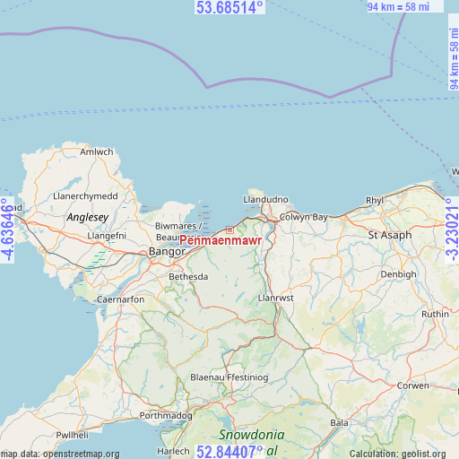
Penmaenmawr GPS coordinates[2]
53° 16' 0.012" North, 3° 55' 59.988" West
| Map corner | latitude | longitude |
|---|---|---|
| Upper-left | 53.68514°, | -4.63646° |
| Center: | 53.26667°, | -3.93333° |
| Lower-right: | 52.84407°, | -3.23021° |
| Map W x H: | 93.5×93.5 km | = 58.1×58.1mi |
| max Lat: | 60.39635° ⇑34.8% North |
| Penmaenmawr: | 53.26667° |
| min Lat: | ⇓65.2% South 34.60088° |
| min Long | Penmaenmawr | max Long |
| -7.64133° | -3.93333° | 32.95536° |
| W 12.7%⇐ | ⇒87.3% E |
Elevation
Elevation of Penmaenmawr is 52 m = 171 ft, and this is 20.9 m = 69 ft below average elevation for this country.
| Max E: |
515 m = 1690 ft | 55.9% |
| Avg. | 72.9 m = 239 ft | |
| Penmaenmawr | 52 m = 171 ft | |
Min E: |
-30 m = -98 ft | 44.1% |
See also: United Kingdom elevation on elevation.city.
Geographical zone
Penmaenmawr is located in North temperate zone (between Tropic of Cancer and the Arctic Circle). Distance of this North polar circle is 1478.5 km =918.7 mi to North.| Distance of | km | miles | from Penmaenmawr |
|---|---|---|---|
| North Pole | 4084.4 | 2537.9 | to North |
| Arctic Circle | 1478.5 | 918.7 | to North |
| Tropic Cancer | 3316.8 | 2061 | to South |
| Equator | 5922.7 | 3680.2 | to South |


Nearby cities:
15 places around Penmaenmawr: (largest is in red/bold)
• Aber
6.7 km =4.2 mi,  236°
236°
• Bangor
13.7 km =8.5 mi,  251°
251°
• Beaumaris
10.6 km =6.6 mi,  267°
267°
• Bethesda
12.6 km =7.8 mi,  221°
221°
• Colwyn Bay
14.1 km =8.8 mi,  77°
77°
• Conwy
7 km =4.3 mi, 77°
• Deganwy
8.2 km =5.1 mi,  59°
59°
• Llanddona
13.8 km =8.6 mi,  282°
282°
• Llandudno
9.4 km =5.8 mi,  46°
46°
• Llanfairfechan
2.9 km =1.8 mi, 250°
• Llangoed
10.7 km =6.6 mi,  286°
286°
• Llansantffraid Glan Conwy
8.9 km =5.5 mi,  90°
90°
• Mochdre
12.3 km =7.6 mi, 81°
• Trefriw
14.7 km =9.1 mi,  150°
150°
• Tregarth
13.3 km =8.3 mi,  230°
230°
Sources, notices
• [Note1] Compared only with cities in United Kingdom existing in our database
• [Src1] Map data: © OpenStreetMap contributors (CC-BY-SA)
• [Src2] Other city data from geonames.org with taken over terms of usage.
• [Src3] Geographical zone / Annual Mean Temperature by Robert A. Rohde @ Wikipedia
