Berwick-Upon-Tweed geodata
Berwick-Upon-Tweed (England) is a populated place; located in United Kingdom in Europe/London (GMT+1) time zone. With population of 13,265 people, there are 852 cities with bigger population in this country. Compared to other cities in United Kingdom, 90.5% of cities are located further ↓South; 55.1% of cities are located further →East and 87% of cities have higher elevation than Berwick-Upon-Tweed. Note1


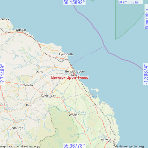
Berwick-Upon-Tweed GPS coordinates[2]
55° 45' 55.296" North, 2° 0' 42.696" West
| Map corner | latitude | longitude |
|---|---|---|
| Upper-left | 56.15892°, | -2.71499° |
| Center: | 55.76536°, | -2.01186° |
| Lower-right: | 55.36778°, | -1.30874° |
| Map W x H: | 88×88 km | = 54.7×54.7mi |
| max Lat: | 60.39635° ⇑9.5% North |
| Berwick-Upon-Tweed: | 55.76536° |
| min Lat: | ⇓90.5% South 34.60088° |
| min Long | Berwick-Upon-Tw | max Long |
| -7.64133° | -2.01186° | 32.95536° |
| W 44.9%⇐ | ⇒55.1% E |
Elevation
Elevation of Berwick-Upon-Tweed is 14 m = 46 ft, and this is 58.9 m = 193 ft below average elevation for this country.
| Max E: |
515 m = 1690 ft | 87% |
| Avg. | 72.9 m = 239 ft | |
| Berwick-Upon-Tweed | 14 m = 46 ft | |
Min E: |
-30 m = -98 ft | 13% |
See also: United Kingdom elevation on elevation.city.
Geographical zone
Berwick-Upon-Tweed is located in North temperate zone (between Tropic of Cancer and the Arctic Circle). Distance of this North polar circle is 1200.6 km =746 mi to North.| Distance of | km | miles | from Berwick-Upon-Tweed |
|---|---|---|---|
| North Pole | 3806.5 | 2365.2 | to North |
| Arctic Circle | 1200.6 | 746 | to North |
| Tropic Cancer | 3594.6 | 2233.6 | to South |
| Equator | 6200.5 | 3852.8 | to South |


Nearby cities:
15 places around Berwick-Upon-Tweed: (largest is in red/bold)
• Allanton
13 km =8.1 mi,  278°
278°
• Ancroft
7.3 km =4.5 mi,  174°
174°
• Ayton
11.1 km =6.9 mi,  320°
320°
• Belford
21.5 km =13.4 mi,  148°
148°
• Chirnside
13 km =8.1 mi,  288°
288°
• Coldingham
16.2 km =10.1 mi,  325°
325°
• Coldstream
19.7 km =12.2 mi,  229°
229°
• Doddington
20 km =12.4 mi,  178°
178°
• Duns
20.9 km =13 mi,  273°
273°
• Eyemouth
12.8 km =8 mi,  337°
337°
• Ford
15.3 km =9.5 mi,  196°
196°
• Kirknewton
25.1 km =15.6 mi, 197°
• Lowick
13 km =8.1 mi, 170°
• Norham
10.8 km =6.7 mi,  241°
241°
• Wooler
24.2 km =15 mi, 180°
Sources, notices
• [Note1] Compared only with cities in United Kingdom existing in our database
• [Src1] Map data: © OpenStreetMap contributors (CC-BY-SA)
• [Src2] Other city data from geonames.org with taken over terms of usage.
• [Src3] Geographical zone / Annual Mean Temperature by Robert A. Rohde @ Wikipedia
